Iron River geodata
Iron River (Wisconsin) is a populated place; located in United States in America/Chicago (GMT-5) time zone. With population of 761 people, there are 18118 cities with bigger population in this country. Compared to other cities in United States, 95.9% of cities are located further ↓South; 62.9% of cities are located further →East and 78% of cities have lower elevation than Iron River. Note1


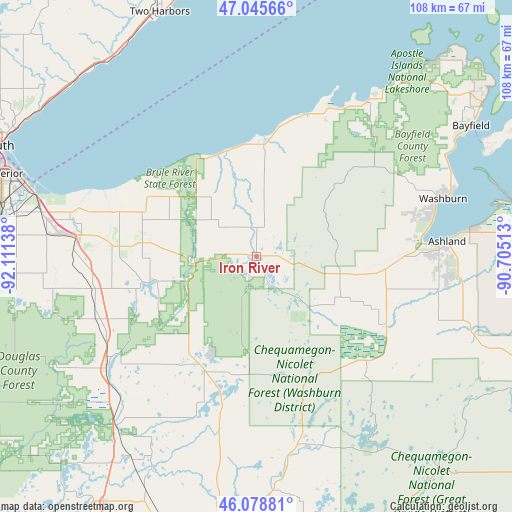
Iron River GPS coordinates[2]
46° 33' 51.804" North, 91° 24' 29.7" West
| Map corner | latitude | longitude |
|---|---|---|
| Upper-left | 47.04566°, | -92.11138° |
| Center: | 46.56439°, | -91.40825° |
| Lower-right: | 46.07881°, | -90.70513° |
| Map W x H: | 107.5×107.5 km | = 66.8×66.8mi |
| max Lat: | 71.29058° ⇑4.1% North |
| Iron River: | 46.56439° |
| min Lat: | ⇓95.9% South 19.06759° |
| min Long | Iron River | max Long |
| -171.73463° | -91.40825° | -66.98998° |
| W 37.1%⇐ | ⇒62.9% E |
Elevation
Elevation of Iron River is 336 m = 1102 ft, and this is 41.2 m = 135 ft above average elevation for this country.
| Max E: |
3189 m = 10463 ft | 22% |
| Iron River | 336 m 1102 ft | |
| Avg. | 294.8 m = 967 ft | |
Min E: |
-60 m = -197 ft | 78% |
See also: United States elevation on elevation.city.
Geographical zone
Iron River is located in North temperate zone (between Tropic of Cancer and the Arctic Circle). Distance of this North polar circle is 2223.7 km =1381.7 mi to North.| Distance of | km | miles | from Iron River |
|---|---|---|---|
| North Pole | 4829.6 | 3001 | to North |
| Arctic Circle | 2223.7 | 1381.7 | to North |
| Tropic Cancer | 2571.6 | 1597.9 | to South |
| Equator | 5177.5 | 3217.1 | to South |


Nearby cities:
15 places around Iron River: (largest is in red/bold)
• Arnold
62.7 km =39 mi,  304°
304°
• Ashland
40.2 km =25 mi,  85°
85°
• Duluth
58.6 km =36.4 mi,  294°
294°
• Hayward
61.6 km =38.3 mi,  185°
185°
• Lake Nebagamon
23 km =14.3 mi,  256°
256°
• Little Round Lake
66.7 km =41.4 mi,  177°
177°
• Mellen
63.1 km =39.2 mi,  114°
114°
• Minong
60.8 km =37.8 mi,  211°
211°
• Poplar
30 km =18.6 mi,  274°
274°
• Proctor
65.6 km =40.8 mi, 288°
• Solon Springs
39.5 km =24.5 mi,  233°
233°
• Superior
55.9 km =34.7 mi, 288°
• Superior Village
54.2 km =33.7 mi,  280°
280°
• Two Harbors
54.7 km =34 mi,  338°
338°
• Washburn
41 km =25.5 mi,  72°
72°
Sources, notices
• [Note1] Compared only with cities in United States existing in our database
• [Src1] Map data: © OpenStreetMap contributors (CC-BY-SA)
• [Src2] Other city data from geonames.org with taken over terms of usage.
• [Src3] Geographical zone / Annual Mean Temperature by Robert A. Rohde @ Wikipedia
