Allenton geodata
Allenton (Wisconsin) is a populated place; located in United States in America/Chicago (GMT-5) time zone. With population of 823 people, there are 17588 cities with bigger population in this country. Compared to other cities in United States, 86% of cities are located further ↓South; 54.3% of cities are located further →East and 71.5% of cities have lower elevation than Allenton. Note1


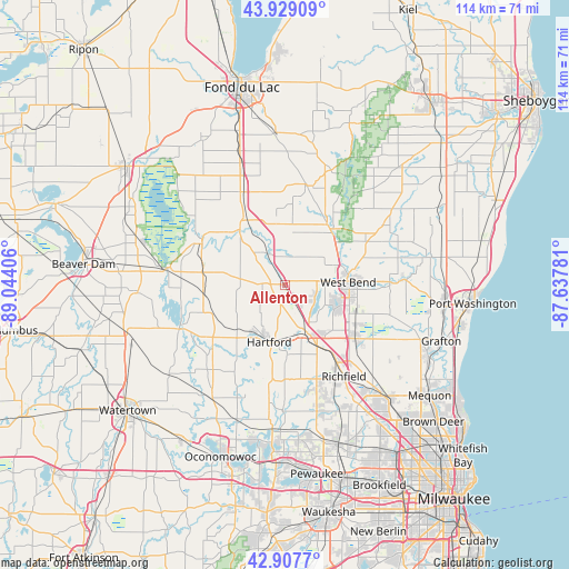
Allenton GPS coordinates[2]
43° 25' 13.98" North, 88° 20' 27.348" West
| Map corner | latitude | longitude |
|---|---|---|
| Upper-left | 43.92909°, | -89.04406° |
| Center: | 43.42055°, | -88.34093° |
| Lower-right: | 42.9077°, | -87.63781° |
| Map W x H: | 113.6×113.6 km | = 70.6×70.6mi |
| max Lat: | 71.29058° ⇑14% North |
| Allenton: | 43.42055° |
| min Lat: | ⇓86% South 19.06759° |
| min Long | Allenton | max Long |
| -171.73463° | -88.34093° | -66.98998° |
| W 45.7%⇐ | ⇒54.3% E |
Elevation
Elevation of Allenton is 293 m = 961 ft, and this is 1.8 m = 6 ft below average elevation for this country.
| Max E: |
3189 m = 10463 ft | 28.5% |
| Avg. | 294.8 m = 967 ft | |
| Allenton | 293 m = 961 ft | |
Min E: |
-60 m = -197 ft | 71.5% |
See also: United States elevation on elevation.city.
Geographical zone
Allenton is located in North temperate zone (between Tropic of Cancer and the Arctic Circle). Distance of this Northern Tropic circle is 2222 km =1380.7 mi to South.| Distance of | km | miles | from Allenton |
|---|---|---|---|
| North Pole | 5179.1 | 3218.1 | to North |
| Arctic Circle | 2573.3 | 1599 | to North |
| Tropic Cancer | 2222 | 1380.7 | to South |
| Equator | 4827.9 | 2999.9 | to South |


Nearby cities:
15 places around Allenton: (largest is in red/bold)
• Addison
2.7 km =1.7 mi,  275°
275°
• Ashford
18.7 km =11.6 mi,  352°
352°
• Barton
13.2 km =8.2 mi,  78°
78°
• Campbellsport
20.3 km =12.6 mi,  14°
14°
• Hartford
11.8 km =7.3 mi,  195°
195°
• Iron Ridge
15.7 km =9.8 mi,  261°
261°
• Jackson
17.7 km =11 mi,  127°
127°
• Kewaskum
14.3 km =8.9 mi,  39°
39°
• Lomira
20.7 km =12.9 mi,  336°
336°
• Mayville
18.4 km =11.4 mi,  296°
296°
• Neosho
18.9 km =11.7 mi,  229°
229°
• Richfield
21.8 km =13.5 mi,  146°
146°
• Slinger
10.6 km =6.6 mi,  155°
155°
• Theresa
14 km =8.7 mi,  320°
320°
• West Bend
12.7 km =7.9 mi,  87°
87°
Sources, notices
• [Note1] Compared only with cities in United States existing in our database
• [Src1] Map data: © OpenStreetMap contributors (CC-BY-SA)
• [Src2] Other city data from geonames.org with taken over terms of usage.
• [Src3] Geographical zone / Annual Mean Temperature by Robert A. Rohde @ Wikipedia
