Mishicot geodata
Mishicot (Wisconsin) is a populated place; located in United States in America/Chicago (GMT-5) time zone. With population of 1,407 people, there are 14080 cities with bigger population in this country. Compared to other cities in United States, 89.4% of cities are located further ↓South; 51.2% of cities are located further →East and 53.9% of cities have higher elevation than Mishicot. Note1
Administrative division(s):
- Level 1: Wisconsin
- Level 2: Manitowoc County
- Level 3: Village of Mishicot


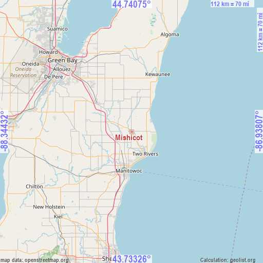
Mishicot GPS coordinates[2]
44° 14' 20.976" North, 87° 38' 28.284" West
| Map corner | latitude | longitude |
|---|---|---|
| Upper-left | 44.74075°, | -88.34432° |
| Center: | 44.23916°, | -87.64119° |
| Lower-right: | 43.73326°, | -86.93807° |
| Map W x H: | 112×112 km | = 69.6×69.6mi |
| max Lat: | 71.29058° ⇑10.6% North |
| Mishicot: | 44.23916° |
| min Lat: | ⇓89.4% South 19.06759° |
| min Long | Mishicot | max Long |
| -171.73463° | -87.64119° | -66.98998° |
| W 48.8%⇐ | ⇒51.2% E |
Elevation
Elevation of Mishicot is 184 m = 604 ft, and this is 110.8 m = 364 ft below average elevation for this country.
| Max E: |
3189 m = 10463 ft | 53.9% |
| Avg. | 294.8 m = 967 ft | |
| Mishicot | 184 m = 604 ft | |
Min E: |
-60 m = -197 ft | 46.1% |
See also: United States elevation on elevation.city.
Geographical zone
Mishicot is located in North temperate zone (between Tropic of Cancer and the Arctic Circle). Distance of this Northern Tropic circle is 2313 km =1437.2 mi to South.| Distance of | km | miles | from Mishicot |
|---|---|---|---|
| North Pole | 5088.1 | 3161.6 | to North |
| Arctic Circle | 2482.2 | 1542.4 | to North |
| Tropic Cancer | 2313 | 1437.2 | to South |
| Equator | 4918.9 | 3056.5 | to South |


Nearby cities:
15 places around Mishicot: (largest is in red/bold)
• Bellevue
31.8 km =19.8 mi,  315°
315°
• Cato
20.6 km =12.8 mi,  238°
238°
• Cooperstown
13.4 km =8.3 mi,  307°
307°
• Denmark
19.1 km =11.9 mi, 309°
• Francis Creek
7.8 km =4.8 mi, 235°
• Glenmore
28 km =17.4 mi, 305°
• Kewaunee
26.7 km =16.6 mi,  24°
24°
• Luxemburg
33.7 km =20.9 mi,  351°
351°
• Manitowoc
16.8 km =10.4 mi,  184°
184°
• Maple Grove
23.2 km =14.4 mi,  256°
256°
• Reedsville
26.9 km =16.7 mi,  249°
249°
• Saint Nazianz
34.1 km =21.2 mi,  221°
221°
• Two Rivers
11.1 km =6.9 mi,  148°
148°
• Valders
27.3 km =17 mi,  225°
225°
• Whitelaw
17.8 km =11.1 mi, 233°
Sources, notices
• [Note1] Compared only with cities in United States existing in our database
• [Src1] Map data: © OpenStreetMap contributors (CC-BY-SA)
• [Src2] Other city data from geonames.org with taken over terms of usage.
• [Src3] Geographical zone / Annual Mean Temperature by Robert A. Rohde @ Wikipedia
