La Crosse geodata
La Crosse (Wisconsin) is a seat of a second-order administrative division; located in United States in America/Chicago (GMT-5) time zone. With population of 52,306 people, there are 898 cities with bigger population in this country. Compared to other cities in United States, 87.6% of cities are located further ↓South; 62.6% of cities are located further →East and 51.2% of cities have lower elevation than La Crosse. Note1


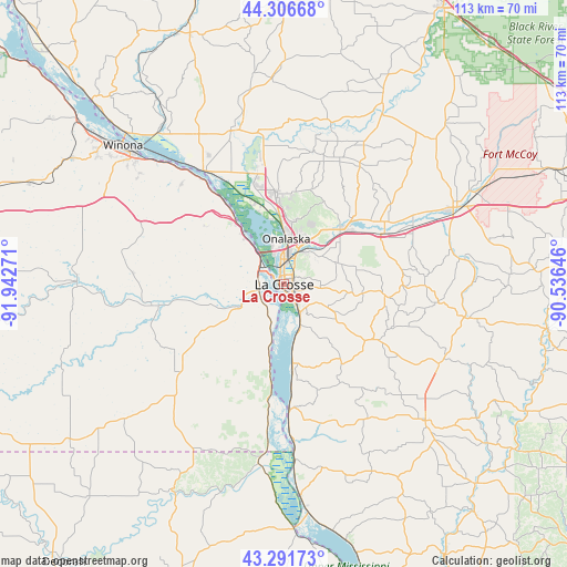
La Crosse GPS coordinates[2]
43° 48' 4.896" North, 91° 14' 22.488" West
| Map corner | latitude | longitude |
|---|---|---|
| Upper-left | 44.30668°, | -91.94271° |
| Center: | 43.80136°, | -91.23958° |
| Lower-right: | 43.29173°, | -90.53646° |
| Map W x H: | 112.9×112.9 km | = 70.2×70.2mi |
| max Lat: | 71.29058° ⇑12.4% North |
| La Crosse: | 43.80136° |
| min Lat: | ⇓87.6% South 19.06759° |
| min Long | La Crosse | max Long |
| -171.73463° | -91.23958° | -66.98998° |
| W 37.4%⇐ | ⇒62.6% E |
Elevation
Elevation of La Crosse is 203 m = 666 ft, and this is 91.8 m = 301 ft below average elevation for this country.
| Max E: |
3189 m = 10463 ft | 48.8% |
| Avg. | 294.8 m = 967 ft | |
| La Crosse | 203 m = 666 ft | |
Min E: |
-60 m = -197 ft | 51.2% |
See also: La Crosse elevation on elevation.city.
Geographical zone
La Crosse is located in North temperate zone (between Tropic of Cancer and the Arctic Circle). Distance of this Northern Tropic circle is 2264.3 km =1407 mi to South.| Distance of | km | miles | from La Crosse |
|---|---|---|---|
| North Pole | 5136.8 | 3191.9 | to North |
| Arctic Circle | 2530.9 | 1572.6 | to North |
| Tropic Cancer | 2264.3 | 1407 | to South |
| Equator | 4870.3 | 3026.3 | to South |


Nearby cities:
15 places around La Crosse: (largest is in red/bold)
• Bangor
22.4 km =13.9 mi,  62°
62°
• Brice Prairie
16 km =9.9 mi,  342°
342°
• Caledonia
27.8 km =17.3 mi,  228°
228°
• Coon Valley
21.3 km =13.2 mi,  121°
121°
• French Island
6.5 km =4 mi,  345°
345°
• Hokah
9.8 km =6.1 mi,  241°
241°
• Holmen
18.1 km =11.2 mi,  355°
355°
• Houston
26.7 km =16.6 mi,  260°
260°
• La Crescent
6 km =3.7 mi,  299°
299°
• North La Crosse
5 km =3.1 mi, 352°
• Onalaska
9.2 km =5.7 mi,  2°
2°
• Saint Joseph
16 km =9.9 mi,  96°
96°
• Stoddard
15.6 km =9.7 mi,  173°
173°
• Trempealeau
27.9 km =17.3 mi,  324°
324°
• West Salem
16.7 km =10.4 mi,  49°
49°
Sources, notices
• [Note1] Compared only with cities in United States existing in our database
• [Src1] Map data: © OpenStreetMap contributors (CC-BY-SA)
• [Src2] Other city data from geonames.org with taken over terms of usage.
• [Src3] Geographical zone / Annual Mean Temperature by Robert A. Rohde @ Wikipedia
