Houston geodata
Houston (Minnesota) is a populated place; located in United States in America/Chicago (GMT-5) time zone. With population of 966 people, there are 16523 cities with bigger population in this country. Compared to other cities in United States, 87.5% of cities are located further ↓South; 63.3% of cities are located further →East and 52.8% of cities have lower elevation than Houston. Note1


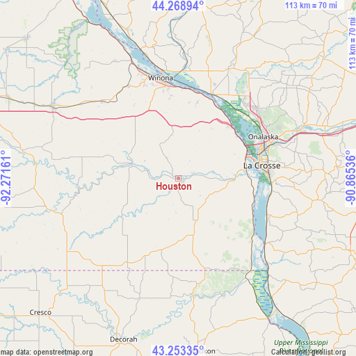
Houston GPS coordinates[2]
43° 45' 47.88" North, 91° 34' 6.528" West
| Map corner | latitude | longitude |
|---|---|---|
| Upper-left | 44.26894°, | -92.27161° |
| Center: | 43.7633°, | -91.56848° |
| Lower-right: | 43.25335°, | -90.86536° |
| Map W x H: | 112.9×112.9 km | = 70.2×70.2mi |
| max Lat: | 71.29058° ⇑12.5% North |
| Houston: | 43.7633° |
| min Lat: | ⇓87.5% South 19.06759° |
| min Long | Houston | max Long |
| -171.73463° | -91.56848° | -66.98998° |
| W 36.7%⇐ | ⇒63.3% E |
Elevation
Elevation of Houston is 209 m = 686 ft, and this is 85.8 m = 281 ft below average elevation for this country.
| Max E: |
3189 m = 10463 ft | 47.2% |
| Avg. | 294.8 m = 967 ft | |
| Houston | 209 m = 686 ft | |
Min E: |
-60 m = -197 ft | 52.8% |
See also: United States elevation on elevation.city.
Geographical zone
Houston is located in North temperate zone (between Tropic of Cancer and the Arctic Circle). Distance of this Northern Tropic circle is 2260.1 km =1404.4 mi to South.| Distance of | km | miles | from Houston |
|---|---|---|---|
| North Pole | 5141 | 3194.5 | to North |
| Arctic Circle | 2535.2 | 1575.3 | to North |
| Tropic Cancer | 2260.1 | 1404.4 | to South |
| Equator | 4866 | 3023.6 | to South |


Nearby cities:
15 places around Houston: (largest is in red/bold)
• Brice Prairie
29 km =18 mi,  47°
47°
• Caledonia
15.4 km =9.6 mi,  158°
158°
• French Island
26.9 km =16.7 mi,  66°
66°
• Hokah
17.8 km =11.1 mi,  91°
91°
• La Crescent
22.4 km =13.9 mi, 71°
• La Crosse
26.7 km =16.6 mi,  80°
80°
• Mabel
31.5 km =19.6 mi,  210°
210°
• North La Crosse
27.3 km =17 mi, 70°
• Onalaska
29.9 km =18.6 mi,  63°
63°
• Rushford
15.6 km =9.7 mi,  288°
288°
• Rushford Village
18.5 km =11.5 mi, 285°
• Spring Grove
23.1 km =14.4 mi,  193°
193°
• Stoddard
30.3 km =18.8 mi,  111°
111°
• Trempealeau
28.8 km =17.9 mi,  20°
20°
• Winona
32.4 km =20.1 mi,  349°
349°
Sources, notices
• [Note1] Compared only with cities in United States existing in our database
• [Src1] Map data: © OpenStreetMap contributors (CC-BY-SA)
• [Src2] Other city data from geonames.org with taken over terms of usage.
• [Src3] Geographical zone / Annual Mean Temperature by Robert A. Rohde @ Wikipedia
