Bangor geodata
Bangor (Wisconsin) is a populated place; located in United States in America/Chicago (GMT-5) time zone. With population of 1,492 people, there are 13693 cities with bigger population in this country. Compared to other cities in United States, 88% of cities are located further ↓South; 62% of cities are located further →East and 56.9% of cities have lower elevation than Bangor. Note1


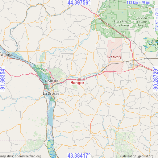
Bangor GPS coordinates[2]
43° 53' 34.872" North, 90° 59' 25.476" West
| Map corner | latitude | longitude |
|---|---|---|
| Upper-left | 44.39756°, | -91.69354° |
| Center: | 43.89302°, | -90.99041° |
| Lower-right: | 43.38417°, | -90.28729° |
| Map W x H: | 112.7×112.7 km | = 70×70mi |
| max Lat: | 71.29058° ⇑12% North |
| Bangor: | 43.89302° |
| min Lat: | ⇓88% South 19.06759° |
| min Long | Bangor | max Long |
| -171.73463° | -90.99041° | -66.98998° |
| W 38%⇐ | ⇒62% E |
Elevation
Elevation of Bangor is 226 m = 741 ft, and this is 68.8 m = 226 ft below average elevation for this country.
| Max E: |
3189 m = 10463 ft | 43.1% |
| Avg. | 294.8 m = 967 ft | |
| Bangor | 226 m = 741 ft | |
Min E: |
-60 m = -197 ft | 56.9% |
See also: United States elevation on elevation.city.
Geographical zone
Bangor is located in North temperate zone (between Tropic of Cancer and the Arctic Circle). Distance of this Northern Tropic circle is 2274.5 km =1413.3 mi to South.| Distance of | km | miles | from Bangor |
|---|---|---|---|
| North Pole | 5126.6 | 3185.5 | to North |
| Arctic Circle | 2520.7 | 1566.3 | to North |
| Tropic Cancer | 2274.5 | 1413.3 | to South |
| Equator | 4880.4 | 3032.5 | to South |


Nearby cities:
15 places around Bangor: (largest is in red/bold)
• Brice Prairie
25.3 km =15.7 mi,  281°
281°
• Cashton
23.9 km =14.9 mi,  134°
134°
• Coon Valley
21.3 km =13.2 mi,  184°
184°
• French Island
22 km =13.7 mi,  259°
259°
• Holmen
22.7 km =14.1 mi,  290°
290°
• La Crescent
26.2 km =16.3 mi,  253°
253°
• La Crosse
22.4 km =13.9 mi,  242°
242°
• North La Crosse
21.3 km =13.2 mi, 255°
• Onalaska
19.6 km =12.2 mi,  267°
267°
• Portland
17.4 km =10.8 mi,  142°
142°
• Rockland
5.9 km =3.7 mi,  75°
75°
• Saint Joseph
12.6 km =7.8 mi,  199°
199°
• Sparta
15.3 km =9.5 mi,  68°
68°
• West Salem
7.3 km =4.5 mi, 275°
• Westby
28.4 km =17.6 mi,  157°
157°
Sources, notices
• [Note1] Compared only with cities in United States existing in our database
• [Src1] Map data: © OpenStreetMap contributors (CC-BY-SA)
• [Src2] Other city data from geonames.org with taken over terms of usage.
• [Src3] Geographical zone / Annual Mean Temperature by Robert A. Rohde @ Wikipedia
