Kenosha geodata
Kenosha (Wisconsin) is a seat of a second-order administrative division; located in United States in America/Chicago (GMT-5) time zone. With population of 99,858 people, there are 350 cities with bigger population in this country. Compared to other cities in United States, 80.4% of cities are located further ↓South; 52% of cities are located further →East and 53.6% of cities have higher elevation than Kenosha. Note1


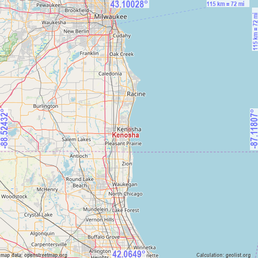
Kenosha GPS coordinates[2]
42° 35' 5.064" North, 87° 49' 16.284" West
| Map corner | latitude | longitude |
|---|---|---|
| Upper-left | 43.10028°, | -88.52432° |
| Center: | 42.58474°, | -87.82119° |
| Lower-right: | 42.0649°, | -87.11807° |
| Map W x H: | 115.1×115.1 km | = 71.5×71.5mi |
| max Lat: | 71.29058° ⇑19.6% North |
| Kenosha: | 42.58474° |
| min Lat: | ⇓80.4% South 19.06759° |
| min Long | Kenosha | max Long |
| -171.73463° | -87.82119° | -66.98998° |
| W 48%⇐ | ⇒52% E |
Elevation
Elevation of Kenosha is 185 m = 607 ft, and this is 109.8 m = 360 ft below average elevation for this country.
| Max E: |
3189 m = 10463 ft | 53.6% |
| Avg. | 294.8 m = 967 ft | |
| Kenosha | 185 m = 607 ft | |
Min E: |
-60 m = -197 ft | 46.4% |
See also: Kenosha elevation on elevation.city.
Geographical zone
Kenosha is located in North temperate zone (between Tropic of Cancer and the Arctic Circle). Distance of this Northern Tropic circle is 2129.1 km =1323 mi to South.| Distance of | km | miles | from Kenosha |
|---|---|---|---|
| North Pole | 5272.1 | 3275.9 | to North |
| Arctic Circle | 2666.2 | 1656.7 | to North |
| Tropic Cancer | 2129.1 | 1323 | to South |
| Equator | 4735 | 2942.2 | to South |


Nearby cities:
15 places around Kenosha: (largest is in red/bold)
• Beach Park
18.3 km =11.4 mi,  189°
189°
• Bristol
18.9 km =11.7 mi,  261°
261°
• Franksville
20.9 km =13 mi,  338°
338°
• Lake Shangrila
22.3 km =13.9 mi,  246°
246°
• Mount Pleasant
12.8 km =8 mi,  347°
347°
• Paddock Lake
23.3 km =14.5 mi,  268°
268°
• Pleasant Prairie
9.8 km =6.1 mi, 249°
• Racine
16 km =9.9 mi,  11°
11°
• Somers
9.6 km =6 mi,  310°
310°
• Sturtevant
14 km =8.7 mi,  334°
334°
• Union Grove
22.1 km =13.7 mi,  301°
301°
• Wadsworth
19.3 km =12 mi,  205°
205°
• Wind Point
22.7 km =14.1 mi, 11°
• Winthrop Harbor
11.8 km =7.3 mi,  180°
180°
• Zion
15.4 km =9.6 mi, 183°
Sources, notices
• [Note1] Compared only with cities in United States existing in our database
• [Src1] Map data: © OpenStreetMap contributors (CC-BY-SA)
• [Src2] Other city data from geonames.org with taken over terms of usage.
• [Src3] Geographical zone / Annual Mean Temperature by Robert A. Rohde @ Wikipedia
