Lukachukai geodata
Lukachukai (Arizona) is a populated place; located in United States in America/Denver (GMT-6) time zone. With population of 1,701 people, there are 12906 cities with bigger population in this country. Compared to other cities in United States, 68.4% of cities are located further ↑North; 85.5% of cities are located further →East and 99.1% of cities have lower elevation than Lukachukai. Note1


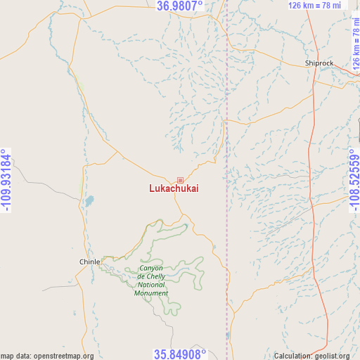
Lukachukai GPS coordinates[2]
36° 25' 1.02" North, 109° 13' 43.356" West
| Map corner | latitude | longitude |
|---|---|---|
| Upper-left | 36.9807°, | -109.93184° |
| Center: | 36.41695°, | -109.22871° |
| Lower-right: | 35.84908°, | -108.52559° |
| Map W x H: | 125.8×125.8 km | = 78.2×78.2mi |
| max Lat: | 71.29058° ⇑68.4% North |
| Lukachukai: | 36.41695° |
| min Lat: | ⇓31.6% South 19.06759° |
| min Long | Lukachukai | max Long |
| -171.73463° | -109.22871° | -66.98998° |
| W 14.5%⇐ | ⇒85.5% E |
Elevation
Elevation of Lukachukai is 1999 m = 6558 ft, and this is 1704.2 m = 5591 ft above average elevation for this country.
| Max E: |
3189 m = 10463 ft | 0.90000000000001% |
| Lukachukai | 1999 m 6558 ft | |
| Avg. | 294.8 m = 967 ft | |
Min E: |
-60 m = -197 ft | 99.1% |
See also: United States elevation on elevation.city.
Geographical zone
Lukachukai is located in North temperate zone (between Tropic of Cancer and the Arctic Circle). Distance of this Northern Tropic circle is 1443.3 km =896.8 mi to South.| Distance of | km | miles | from Lukachukai |
|---|---|---|---|
| North Pole | 5957.9 | 3702.1 | to North |
| Arctic Circle | 3352 | 2082.8 | to North |
| Tropic Cancer | 1443.3 | 896.8 | to South |
| Equator | 4049.2 | 2516.1 | to South |


Nearby cities:
15 places around Lukachukai: (largest is in red/bold)
• Chilchinbito
77.3 km =48 mi,  279°
279°
• Chinle
41.2 km =25.6 mi,  224°
224°
• Dennehotso
72.9 km =45.3 mi,  310°
310°
• Fort Defiance
76 km =47.2 mi,  169°
169°
• Many Farms
35.6 km =22.1 mi,  258°
258°
• Navajo
60.1 km =37.3 mi,  163°
163°
• Nenahnezad
80.6 km =50.1 mi,  63°
63°
• Rock Point
48.8 km =30.3 mi, 313°
• Round Rock
24.4 km =15.2 mi,  296°
296°
• Sawmill
57.5 km =35.7 mi, 174°
• Shiprock
63.4 km =39.4 mi,  49°
49°
• Teec Nos Pos
57.5 km =35.7 mi,  12°
12°
• Tohatchi
74.9 km =46.5 mi,  145°
145°
• Tsaile
12.7 km =7.9 mi, 174°
• Waterflow
76.8 km =47.7 mi, 60°
Sources, notices
• [Note1] Compared only with cities in United States existing in our database
• [Src1] Map data: © OpenStreetMap contributors (CC-BY-SA)
• [Src2] Other city data from geonames.org with taken over terms of usage.
• [Src3] Geographical zone / Annual Mean Temperature by Robert A. Rohde @ Wikipedia
