Chinle geodata
Chinle (Arizona) is a populated place; located in United States in America/Denver (GMT-6) time zone. With population of 4,518 people, there are 7629 cities with bigger population in this country. Compared to other cities in United States, 69.6% of cities are located further ↑North; 85.6% of cities are located further →East and 97.8% of cities have lower elevation than Chinle. Note1


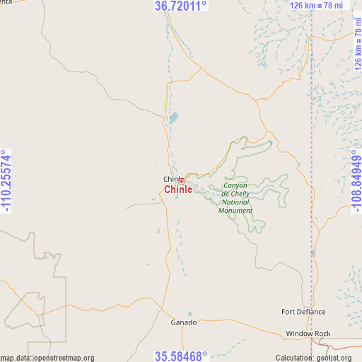
Chinle GPS coordinates[2]
36° 9' 16.02" North, 109° 33' 9.396" West
| Map corner | latitude | longitude |
|---|---|---|
| Upper-left | 36.72011°, | -110.25574° |
| Center: | 36.15445°, | -109.55261° |
| Lower-right: | 35.58468°, | -108.84949° |
| Map W x H: | 126.2×126.2 km | = 78.4×78.4mi |
| max Lat: | 71.29058° ⇑69.6% North |
| Chinle: | 36.15445° |
| min Lat: | ⇓30.4% South 19.06759° |
| min Long | Chinle | max Long |
| -171.73463° | -109.55261° | -66.98998° |
| W 14.4%⇐ | ⇒85.6% E |
Elevation
Elevation of Chinle is 1682 m = 5518 ft, and this is 1387.2 m = 4551 ft above average elevation for this country.
| Max E: |
3189 m = 10463 ft | 2.2% |
| Chinle | 1682 m 5518 ft | |
| Avg. | 294.8 m = 967 ft | |
Min E: |
-60 m = -197 ft | 97.8% |
See also: United States elevation on elevation.city.
Geographical zone
Chinle is located in North temperate zone (between Tropic of Cancer and the Arctic Circle). Distance of this Northern Tropic circle is 1414.1 km =878.7 mi to South.| Distance of | km | miles | from Chinle |
|---|---|---|---|
| North Pole | 5987.1 | 3720.2 | to North |
| Arctic Circle | 3381.2 | 2101 | to North |
| Tropic Cancer | 1414.1 | 878.7 | to South |
| Equator | 4020 | 2497.9 | to South |


Nearby cities:
15 places around Chinle: (largest is in red/bold)
• Burnside
45.3 km =28.1 mi,  188°
188°
• Chilchinbito
63 km =39.1 mi,  311°
311°
• Fort Defiance
62.6 km =38.9 mi,  136°
136°
• Ganado
49.3 km =30.6 mi,  178°
178°
• Low Mountain
55.8 km =34.7 mi,  244°
244°
• Lukachukai
41.2 km =25.6 mi,  44°
44°
• Many Farms
22.8 km =14.2 mi,  345°
345°
• Navajo
54.5 km =33.9 mi,  121°
121°
• Pinon
60.8 km =37.8 mi,  264°
264°
• Rock Point
63 km =39.1 mi, 354°
• Round Rock
40.5 km =25.2 mi,  10°
10°
• Saint Michaels
70 km =43.5 mi, 144°
• Sawmill
44.7 km =27.8 mi,  128°
128°
• Tsaile
34.5 km =21.4 mi,  61°
61°
• Window Rock
69.3 km =43.1 mi, 139°
Sources, notices
• [Note1] Compared only with cities in United States existing in our database
• [Src1] Map data: © OpenStreetMap contributors (CC-BY-SA)
• [Src2] Other city data from geonames.org with taken over terms of usage.
• [Src3] Geographical zone / Annual Mean Temperature by Robert A. Rohde @ Wikipedia
