Dennehotso geodata
Dennehotso (Arizona) is a populated place; located in United States in America/Denver (GMT-6) time zone. With population of 746 people, there are 18241 cities with bigger population in this country. Compared to other cities in United States, 66.8% of cities are located further ↑North; 85.7% of cities are located further →East and 96.9% of cities have lower elevation than Dennehotso. Note1


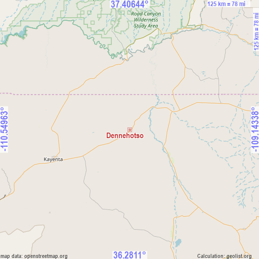
Dennehotso GPS coordinates[2]
36° 50' 45.024" North, 109° 50' 47.4" West
| Map corner | latitude | longitude |
|---|---|---|
| Upper-left | 37.40644°, | -110.54963° |
| Center: | 36.84584°, | -109.8465° |
| Lower-right: | 36.2811°, | -109.14338° |
| Map W x H: | 125.1×125.1 km | = 77.7×77.7mi |
| max Lat: | 71.29058° ⇑66.8% North |
| Dennehotso: | 36.84584° |
| min Lat: | ⇓33.2% South 19.06759° |
| min Long | Dennehotso | max Long |
| -171.73463° | -109.8465° | -66.98998° |
| W 14.3%⇐ | ⇒85.7% E |
Elevation
Elevation of Dennehotso is 1531 m = 5023 ft, and this is 1236.2 m = 4056 ft above average elevation for this country.
| Max E: |
3189 m = 10463 ft | 3.1% |
| Dennehotso | 1531 m 5023 ft | |
| Avg. | 294.8 m = 967 ft | |
Min E: |
-60 m = -197 ft | 96.9% |
See also: United States elevation on elevation.city.
Geographical zone
Dennehotso is located in North temperate zone (between Tropic of Cancer and the Arctic Circle). Distance of this Northern Tropic circle is 1491 km =926.5 mi to South.| Distance of | km | miles | from Dennehotso |
|---|---|---|---|
| North Pole | 5910.2 | 3672.4 | to North |
| Arctic Circle | 3304.3 | 2053.2 | to North |
| Tropic Cancer | 1491 | 926.5 | to South |
| Equator | 4096.9 | 2545.7 | to South |


Nearby cities:
15 places around Dennehotso: (largest is in red/bold)
• Aneth
71.6 km =44.5 mi,  54°
54°
• Blanding
92.5 km =57.5 mi,  20°
20°
• Chilchinbito
41.2 km =25.6 mi,  210°
210°
• Chinle
81.2 km =50.5 mi,  161°
161°
• Kayenta
38.6 km =24 mi,  250°
250°
• Lukachukai
72.9 km =45.3 mi,  130°
130°
• Many Farms
58.5 km =36.4 mi, 159°
• Oljato-Monument Valley
41.4 km =25.7 mi,  299°
299°
• Pinon
89.5 km =55.6 mi,  202°
202°
• Rock Point
24.2 km =15 mi, 125°
• Round Rock
49.8 km =30.9 mi,  138°
138°
• Shiprock
103.4 km =64.2 mi,  93°
93°
• Shonto
76.2 km =47.3 mi, 248°
• Teec Nos Pos
68.2 km =42.4 mi,  82°
82°
• Tsaile
82.5 km =51.3 mi, 136°
Sources, notices
• [Note1] Compared only with cities in United States existing in our database
• [Src1] Map data: © OpenStreetMap contributors (CC-BY-SA)
• [Src2] Other city data from geonames.org with taken over terms of usage.
• [Src3] Geographical zone / Annual Mean Temperature by Robert A. Rohde @ Wikipedia
