Sawmill geodata
Sawmill (Arizona) is a populated place; located in United States in America/Denver (GMT-6) time zone. With population of 748 people, there are 18223 cities with bigger population in this country. Compared to other cities in United States, 70.9% of cities are located further ↑North; 85.4% of cities are located further →East and 99.7% of cities have lower elevation than Sawmill. Note1


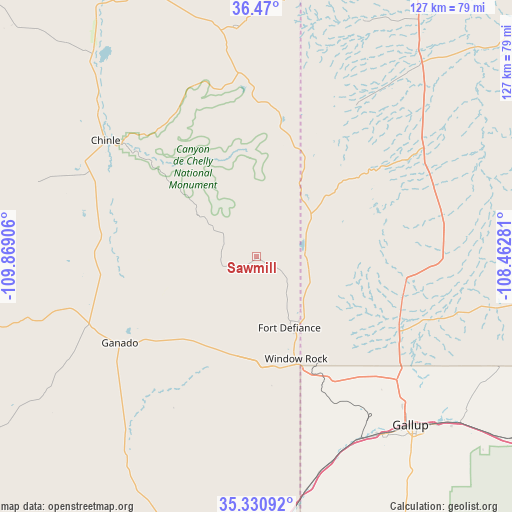
Sawmill GPS coordinates[2]
35° 54' 9.036" North, 109° 9' 57.348" West
| Map corner | latitude | longitude |
|---|---|---|
| Upper-left | 36.47°, | -109.86906° |
| Center: | 35.90251°, | -109.16593° |
| Lower-right: | 35.33092°, | -108.46281° |
| Map W x H: | 126.7×126.7 km | = 78.7×78.7mi |
| max Lat: | 71.29058° ⇑70.9% North |
| Sawmill: | 35.90251° |
| min Lat: | ⇓29.1% South 19.06759° |
| min Long | Sawmill | max Long |
| -171.73463° | -109.16593° | -66.98998° |
| W 14.6%⇐ | ⇒85.4% E |
Elevation
Elevation of Sawmill is 2341 m = 7680 ft, and this is 2046.2 m = 6713 ft above average elevation for this country.
| Max E: |
3189 m = 10463 ft | 0.3% |
| Sawmill | 2341 m 7680 ft | |
| Avg. | 294.8 m = 967 ft | |
Min E: |
-60 m = -197 ft | 99.7% |
See also: United States elevation on elevation.city.
Geographical zone
Sawmill is located in North temperate zone (between Tropic of Cancer and the Arctic Circle). Distance of this Northern Tropic circle is 1386.1 km =861.3 mi to South.| Distance of | km | miles | from Sawmill |
|---|---|---|---|
| North Pole | 6015.1 | 3737.6 | to North |
| Arctic Circle | 3409.2 | 2118.4 | to North |
| Tropic Cancer | 1386.1 | 861.3 | to South |
| Equator | 3992 | 2480.5 | to South |


Nearby cities:
15 places around Sawmill: (largest is in red/bold)
• Burnside
44.6 km =27.7 mi,  247°
247°
• Chinle
44.7 km =27.8 mi,  308°
308°
• Fort Defiance
19.3 km =12 mi,  155°
155°
• Gallup
56.5 km =35.1 mi,  137°
137°
• Ganado
40 km =24.9 mi,  237°
237°
• Lukachukai
57.5 km =35.7 mi,  354°
354°
• Many Farms
64.5 km =40.1 mi,  320°
320°
• Navajo
11.9 km =7.4 mi,  91°
91°
• Rock Springs
44.5 km =27.7 mi, 137°
• Saint Michaels
29.4 km =18.3 mi,  167°
167°
• Tohatchi
36.8 km =22.9 mi,  97°
97°
• Tsaile
44.8 km =27.8 mi, 354°
• Twin Lakes
41.3 km =25.7 mi,  121°
121°
• Window Rock
26.7 km =16.6 mi, 157°
• Yah-ta-hey
46.3 km =28.8 mi,  131°
131°
Sources, notices
• [Note1] Compared only with cities in United States existing in our database
• [Src1] Map data: © OpenStreetMap contributors (CC-BY-SA)
• [Src2] Other city data from geonames.org with taken over terms of usage.
• [Src3] Geographical zone / Annual Mean Temperature by Robert A. Rohde @ Wikipedia
