Salome geodata
Salome (Arizona) is a populated place; located in United States in America/Phoenix (GMT-7) time zone. With population of 1,530 people, there are 13544 cities with bigger population in this country. Compared to other cities in United States, 81.6% of cities are located further ↑North; 88.3% of cities are located further →East and 89.2% of cities have lower elevation than Salome. Note1


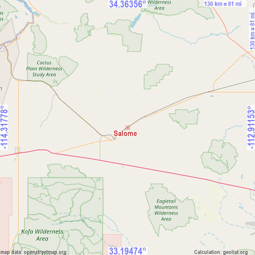
Salome GPS coordinates[2]
33° 46' 52.104" North, 113° 36' 52.74" West
| Map corner | latitude | longitude |
|---|---|---|
| Upper-left | 34.36356°, | -114.31778° |
| Center: | 33.78114°, | -113.61465° |
| Lower-right: | 33.19474°, | -112.91153° |
| Map W x H: | 130×130 km | = 80.8×80.8mi |
| max Lat: | 71.29058° ⇑81.6% North |
| Salome: | 33.78114° |
| min Lat: | ⇓18.4% South 19.06759° |
| min Long | Salome | max Long |
| -171.73463° | -113.61465° | -66.98998° |
| W 11.7%⇐ | ⇒88.3% E |
Elevation
Elevation of Salome is 571 m = 1873 ft, and this is 276.2 m = 906 ft above average elevation for this country.
| Max E: |
3189 m = 10463 ft | 10.8% |
| Salome | 571 m 1873 ft | |
| Avg. | 294.8 m = 967 ft | |
Min E: |
-60 m = -197 ft | 89.2% |
See also: United States elevation on elevation.city.
Geographical zone
Salome is located in North temperate zone (between Tropic of Cancer and the Arctic Circle). Distance of this Northern Tropic circle is 1150.2 km =714.7 mi to South.| Distance of | km | miles | from Salome |
|---|---|---|---|
| North Pole | 6251 | 3884.2 | to North |
| Arctic Circle | 3645.1 | 2265 | to North |
| Tropic Cancer | 1150.2 | 714.7 | to South |
| Equator | 3756.1 | 2333.9 | to South |


Nearby cities:
15 places around Salome: (largest is in red/bold)
• Aguila
44.5 km =27.7 mi,  66°
66°
• Big River
79.6 km =49.5 mi,  300°
300°
• Bluewater
73.8 km =45.9 mi,  305°
305°
• Bouse
39.8 km =24.7 mi,  294°
294°
• Brenda
32.5 km =20.2 mi,  249°
249°
• Cienega Springs
72.2 km =44.9 mi, 308°
• Congress
82.2 km =51.1 mi,  58°
58°
• Ehrenberg
86.5 km =53.7 mi,  256°
256°
• La Paz Valley
62.3 km =38.7 mi, 248°
• Parker
74.5 km =46.3 mi, 303°
• Parker Strip
72.6 km =45.1 mi, 312°
• Quartzsite
58.4 km =36.3 mi, 257°
• Vicksburg
13.3 km =8.3 mi, 252°
• Wenden
8.2 km =5.1 mi, 55°
• Wickenburg
84.3 km =52.4 mi,  75°
75°
Sources, notices
• [Note1] Compared only with cities in United States existing in our database
• [Src1] Map data: © OpenStreetMap contributors (CC-BY-SA)
• [Src2] Other city data from geonames.org with taken over terms of usage.
• [Src3] Geographical zone / Annual Mean Temperature by Robert A. Rohde @ Wikipedia
