Sells geodata
Sells (Arizona) is a populated place; located in United States in America/Phoenix (GMT-7) time zone. With population of 2,495 people, there are 10624 cities with bigger population in this country. Compared to other cities in United States, 88.8% of cities are located further ↑North; 87.2% of cities are located further →East and 91.2% of cities have lower elevation than Sells. Note1


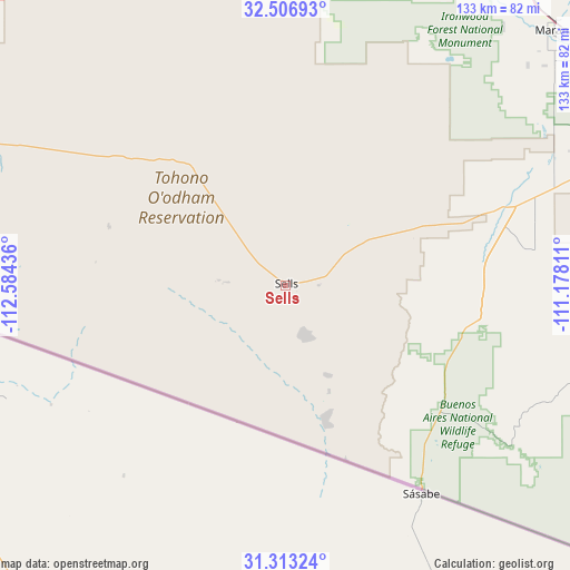
Sells GPS coordinates[2]
31° 54' 43.272" North, 111° 52' 52.428" West
| Map corner | latitude | longitude |
|---|---|---|
| Upper-left | 32.50693°, | -112.58436° |
| Center: | 31.91202°, | -111.88123° |
| Lower-right: | 31.31324°, | -111.17811° |
| Map W x H: | 132.7×132.7 km | = 82.5×82.5mi |
| max Lat: | 71.29058° ⇑88.8% North |
| Sells: | 31.91202° |
| min Lat: | ⇓11.2% South 19.06759° |
| min Long | Sells | max Long |
| -171.73463° | -111.88123° | -66.98998° |
| W 12.8%⇐ | ⇒87.2% E |
Elevation
Elevation of Sells is 730 m = 2395 ft, and this is 435.2 m = 1428 ft above average elevation for this country.
| Max E: |
3189 m = 10463 ft | 8.8% |
| Sells | 730 m 2395 ft | |
| Avg. | 294.8 m = 967 ft | |
Min E: |
-60 m = -197 ft | 91.2% |
See also: United States elevation on elevation.city.
Geographical zone
Sells is located in North temperate zone (between Tropic of Cancer and the Arctic Circle). Distance of this Northern Tropic circle is 942.4 km =585.6 mi to South.| Distance of | km | miles | from Sells |
|---|---|---|---|
| North Pole | 6458.8 | 4013.3 | to North |
| Arctic Circle | 3852.9 | 2394.1 | to North |
| Tropic Cancer | 942.4 | 585.6 | to South |
| Equator | 3548.3 | 2204.8 | to South |


Nearby cities:
15 places around Sells: (largest is in red/bold)
• Arivaca
64 km =39.8 mi,  125°
125°
• Arivaca Junction
80.2 km =49.8 mi,  104°
104°
• Avra Valley
79.1 km =49.2 mi,  42°
42°
• Drexel Heights
84.3 km =52.4 mi,  72°
72°
• East Sahuarita
90 km =55.9 mi,  87°
87°
• Green Valley
84 km =52.2 mi, 94°
• Marana
84.9 km =52.8 mi,  46°
46°
• Picture Rocks
76.8 km =47.7 mi, 51°
• Sahuarita
87.5 km =54.4 mi, 86°
• Santa Rosa
48.2 km =30 mi,  341°
341°
• Summit
89.4 km =55.6 mi,  78°
78°
• Three Points
56.6 km =35.2 mi, 71°
• Tubac
85.7 km =53.3 mi,  112°
112°
• Tucson Estates
80.5 km =50 mi, 67°
• Valencia West
76.4 km =47.5 mi, 71°
Sources, notices
• [Note1] Compared only with cities in United States existing in our database
• [Src1] Map data: © OpenStreetMap contributors (CC-BY-SA)
• [Src2] Other city data from geonames.org with taken over terms of usage.
• [Src3] Geographical zone / Annual Mean Temperature by Robert A. Rohde @ Wikipedia
