Superior geodata
Superior (Arizona) is a populated place; located in United States in America/Phoenix (GMT-7) time zone. With population of 2,943 people, there are 9731 cities with bigger population in this country. Compared to other cities in United States, 84% of cities are located further ↑North; 86.3% of cities are located further →East and 92.5% of cities have lower elevation than Superior. Note1


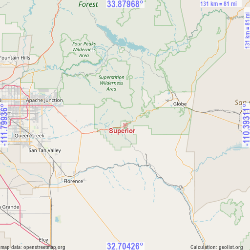
Superior GPS coordinates[2]
33° 17' 38.22" North, 111° 5' 46.428" West
| Map corner | latitude | longitude |
|---|---|---|
| Upper-left | 33.87968°, | -111.79936° |
| Center: | 33.29395°, | -111.09623° |
| Lower-right: | 32.70426°, | -110.39311° |
| Map W x H: | 130.7×130.7 km | = 81.2×81.2mi |
| max Lat: | 71.29058° ⇑84% North |
| Superior: | 33.29395° |
| min Lat: | ⇓16% South 19.06759° |
| min Long | Superior | max Long |
| -171.73463° | -111.09623° | -66.98998° |
| W 13.7%⇐ | ⇒86.3% E |
Elevation
Elevation of Superior is 867 m = 2844 ft, and this is 572.2 m = 1877 ft above average elevation for this country.
| Max E: |
3189 m = 10463 ft | 7.5% |
| Superior | 867 m 2844 ft | |
| Avg. | 294.8 m = 967 ft | |
Min E: |
-60 m = -197 ft | 92.5% |
See also: United States elevation on elevation.city.
Geographical zone
Superior is located in North temperate zone (between Tropic of Cancer and the Arctic Circle). Distance of this Northern Tropic circle is 1096 km =681 mi to South.| Distance of | km | miles | from Superior |
|---|---|---|---|
| North Pole | 6305.1 | 3917.8 | to North |
| Arctic Circle | 3699.2 | 2298.6 | to North |
| Tropic Cancer | 1096 | 681 | to South |
| Equator | 3701.9 | 2300.3 | to South |


Nearby cities:
15 places around Superior: (largest is in red/bold)
• Apache Junction
44.2 km =27.5 mi,  287°
287°
• Cactus Forest
42.6 km =26.5 mi,  209°
209°
• Central Heights-Midland City
28.8 km =17.9 mi,  64°
64°
• Claypool
26.9 km =16.7 mi, 61°
• Dudleyville
46.6 km =29 mi,  140°
140°
• Florence
39.8 km =24.7 mi,  222°
222°
• Globe
30.9 km =19.2 mi,  68°
68°
• Gold Camp
19.3 km =12 mi,  269°
269°
• Gold Canyon
32.8 km =20.4 mi, 285°
• Hayden
43.3 km =26.9 mi, 138°
• Kearny
31.5 km =19.6 mi,  146°
146°
• Miami
24.2 km =15 mi, 61°
• Queen Valley
18 km =11.2 mi, 271°
• San Tan Valley
41.7 km =25.9 mi,  254°
254°
• Six Shooter Canyon
31 km =19.3 mi, 74°
Sources, notices
• [Note1] Compared only with cities in United States existing in our database
• [Src1] Map data: © OpenStreetMap contributors (CC-BY-SA)
• [Src2] Other city data from geonames.org with taken over terms of usage.
• [Src3] Geographical zone / Annual Mean Temperature by Robert A. Rohde @ Wikipedia
