Florence geodata
Florence (Arizona) is a seat of a second-order administrative division; located in United States in America/Phoenix (GMT-7) time zone. With population of 31,110 people, there are 1591 cities with bigger population in this country. Compared to other cities in United States, 85% of cities are located further ↑North; 86.5% of cities are located further →East and 86.5% of cities have lower elevation than Florence. Note1


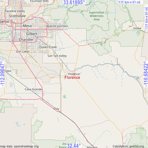
Florence GPS coordinates[2]
33° 1' 53.22" North, 111° 23' 14.424" West
| Map corner | latitude | longitude |
|---|---|---|
| Upper-left | 33.61895°, | -112.09047° |
| Center: | 33.03145°, | -111.38734° |
| Lower-right: | 32.44°, | -110.68422° |
| Map W x H: | 131.1×131.1 km | = 81.5×81.5mi |
| max Lat: | 71.29058° ⇑85% North |
| Florence: | 33.03145° |
| min Lat: | ⇓15% South 19.06759° |
| min Long | Florence | max Long |
| -171.73463° | -111.38734° | -66.98998° |
| W 13.5%⇐ | ⇒86.5% E |
Elevation
Elevation of Florence is 453 m = 1486 ft, and this is 158.2 m = 519 ft above average elevation for this country.
| Max E: |
3189 m = 10463 ft | 13.5% |
| Florence | 453 m 1486 ft | |
| Avg. | 294.8 m = 967 ft | |
Min E: |
-60 m = -197 ft | 86.5% |
See also: United States elevation on elevation.city.
Geographical zone
Florence is located in North temperate zone (between Tropic of Cancer and the Arctic Circle). Distance of this Northern Tropic circle is 1066.8 km =662.9 mi to South.| Distance of | km | miles | from Florence |
|---|---|---|---|
| North Pole | 6334.3 | 3936 | to North |
| Arctic Circle | 3728.4 | 2316.7 | to North |
| Tropic Cancer | 1066.8 | 662.9 | to South |
| Equator | 3672.8 | 2282.2 | to South |


Nearby cities:
15 places around Florence: (largest is in red/bold)
• Arizona City
40.5 km =25.2 mi,  220°
220°
• Blackwater
18.2 km =11.3 mi,  269°
269°
• Cactus Forest
10.1 km =6.3 mi,  141°
141°
• Casa Grande
38.4 km =23.9 mi,  243°
243°
• Coolidge
13.5 km =8.4 mi, 243°
• Eloy
34.4 km =21.4 mi,  207°
207°
• Gold Camp
30.2 km =18.8 mi,  14°
14°
• Gold Canyon
38.1 km =23.7 mi,  353°
353°
• Kearny
44.5 km =27.7 mi,  86°
86°
• Queen Creek
33.3 km =20.7 mi,  316°
316°
• Queen Valley
31.1 km =19.3 mi,  17°
17°
• Sacaton
33.2 km =20.6 mi,  278°
278°
• San Tan Valley
22.1 km =13.7 mi, 323°
• Santan
41.6 km =25.8 mi,  292°
292°
• Superior
39.8 km =24.7 mi,  42°
42°
Sources, notices
• [Note1] Compared only with cities in United States existing in our database
• [Src1] Map data: © OpenStreetMap contributors (CC-BY-SA)
• [Src2] Other city data from geonames.org with taken over terms of usage.
• [Src3] Geographical zone / Annual Mean Temperature by Robert A. Rohde @ Wikipedia
