Cactus Forest geodata
Cactus Forest (Arizona) is a populated place; located in United States in America/Phoenix (GMT-7) time zone. With population of 594 people, there are 19769 cities with bigger population in this country. Compared to other cities in United States, 85.3% of cities are located further ↑North; 86.5% of cities are located further →East and 88.8% of cities have lower elevation than Cactus Forest. Note1


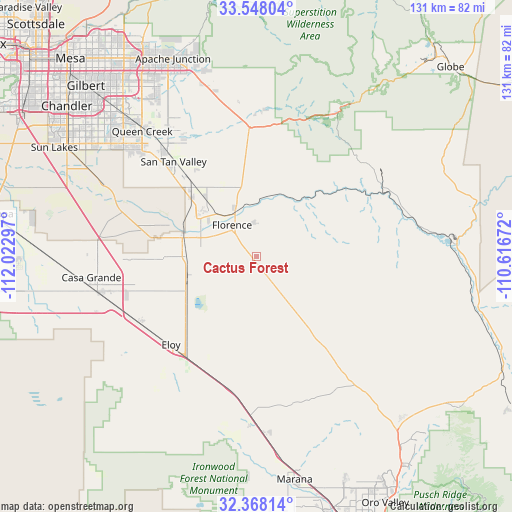
Cactus Forest GPS coordinates[2]
32° 57' 36.216" North, 111° 19' 11.424" West
| Map corner | latitude | longitude |
|---|---|---|
| Upper-left | 33.54804°, | -112.02297° |
| Center: | 32.96006°, | -111.31984° |
| Lower-right: | 32.36814°, | -110.61672° |
| Map W x H: | 131.2×131.2 km | = 81.5×81.5mi |
| max Lat: | 71.29058° ⇑85.3% North |
| Cactus Forest: | 32.96006° |
| min Lat: | ⇓14.7% South 19.06759° |
| min Long | Cactus Forest | max Long |
| -171.73463° | -111.31984° | -66.98998° |
| W 13.5%⇐ | ⇒86.5% E |
Elevation
Elevation of Cactus Forest is 550 m = 1804 ft, and this is 255.2 m = 837 ft above average elevation for this country.
| Max E: |
3189 m = 10463 ft | 11.2% |
| Cactus Forest | 550 m 1804 ft | |
| Avg. | 294.8 m = 967 ft | |
Min E: |
-60 m = -197 ft | 88.8% |
See also: United States elevation on elevation.city.
Geographical zone
Cactus Forest is located in North temperate zone (between Tropic of Cancer and the Arctic Circle). Distance of this Northern Tropic circle is 1058.9 km =658 mi to South.| Distance of | km | miles | from Cactus Forest |
|---|---|---|---|
| North Pole | 6342.2 | 3940.9 | to North |
| Arctic Circle | 3736.4 | 2321.7 | to North |
| Tropic Cancer | 1058.9 | 658 | to South |
| Equator | 3664.8 | 2277.2 | to South |


Nearby cities:
15 places around Cactus Forest: (largest is in red/bold)
• Arizona City
39.9 km =24.8 mi,  235°
235°
• Blackwater
25.8 km =16 mi,  287°
287°
• Casa Grande
41.8 km =26 mi,  257°
257°
• Coolidge
18.6 km =11.6 mi,  276°
276°
• Eloy
31.6 km =19.6 mi,  224°
224°
• Florence
10.1 km =6.3 mi,  321°
321°
• Gold Camp
37.1 km =23.1 mi,  2°
2°
• Gold Canyon
47 km =29.2 mi,  346°
346°
• Hayden
50.1 km =31.1 mi,  84°
84°
• Kearny
39.6 km =24.6 mi,  74°
74°
• Queen Creek
43.4 km =27 mi, 317°
• Queen Valley
37.8 km =23.5 mi, 4°
• Sacaton
41.2 km =25.6 mi, 288°
• San Tan Valley
32.2 km =20 mi, 322°
• Superior
42.6 km =26.5 mi,  29°
29°
Sources, notices
• [Note1] Compared only with cities in United States existing in our database
• [Src1] Map data: © OpenStreetMap contributors (CC-BY-SA)
• [Src2] Other city data from geonames.org with taken over terms of usage.
• [Src3] Geographical zone / Annual Mean Temperature by Robert A. Rohde @ Wikipedia
