Gold Canyon geodata
Gold Canyon (Arizona) is a populated place; located in United States in America/Phoenix (GMT-7) time zone. With population of 10,159 people, there are 4416 cities with bigger population in this country. Compared to other cities in United States, 83.7% of cities are located further ↑North; 86.6% of cities are located further →East and 89.3% of cities have lower elevation than Gold Canyon. Note1


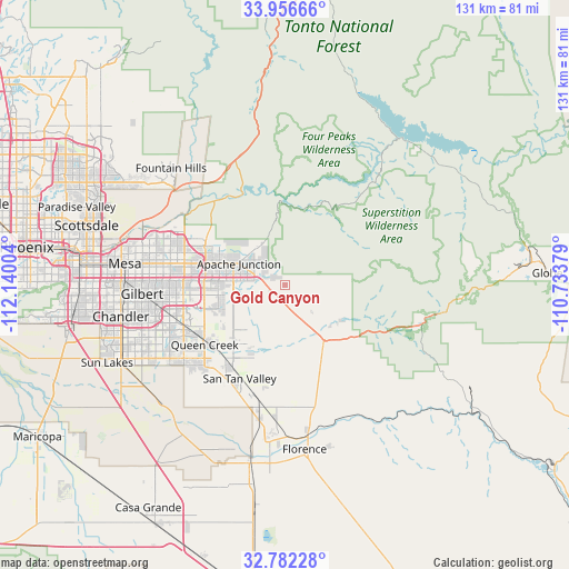
Gold Canyon GPS coordinates[2]
33° 22' 17.22" North, 111° 26' 12.876" West
| Map corner | latitude | longitude |
|---|---|---|
| Upper-left | 33.95666°, | -112.14004° |
| Center: | 33.37145°, | -111.43691° |
| Lower-right: | 32.78228°, | -110.73379° |
| Map W x H: | 130.6×130.6 km | = 81.2×81.2mi |
| max Lat: | 71.29058° ⇑83.7% North |
| Gold Canyon: | 33.37145° |
| min Lat: | ⇓16.3% South 19.06759° |
| min Long | Gold Canyon | max Long |
| -171.73463° | -111.43691° | -66.98998° |
| W 13.4%⇐ | ⇒86.6% E |
Elevation
Elevation of Gold Canyon is 579 m = 1900 ft, and this is 284.2 m = 932 ft above average elevation for this country.
| Max E: |
3189 m = 10463 ft | 10.7% |
| Gold Canyon | 579 m 1900 ft | |
| Avg. | 294.8 m = 967 ft | |
Min E: |
-60 m = -197 ft | 89.3% |
See also: United States elevation on elevation.city.
Geographical zone
Gold Canyon is located in North temperate zone (between Tropic of Cancer and the Arctic Circle). Distance of this Northern Tropic circle is 1104.6 km =686.4 mi to South.| Distance of | km | miles | from Gold Canyon |
|---|---|---|---|
| North Pole | 6296.5 | 3912.5 | to North |
| Arctic Circle | 3690.6 | 2293.2 | to North |
| Tropic Cancer | 1104.6 | 686.4 | to South |
| Equator | 3710.6 | 2305.7 | to South |


Nearby cities:
15 places around Gold Canyon: (largest is in red/bold)
• Apache Junction
11.5 km =7.1 mi,  294°
294°
• Blackwater
40.2 km =25 mi,  199°
199°
• Chandler
38.3 km =23.8 mi,  259°
259°
• Florence
38.1 km =23.7 mi,  173°
173°
• Fountain Hills
37.3 km =23.2 mi,  315°
315°
• Gilbert
32.8 km =20.4 mi,  266°
266°
• Gold Camp
15.1 km =9.4 mi,  125°
125°
• Mesa
36.3 km =22.6 mi,  278°
278°
• Queen Creek
22.9 km =14.2 mi,  233°
233°
• Queen Valley
15.9 km =9.9 mi,  120°
120°
• Sacaton
43.2 km =26.8 mi,  220°
220°
• San Carlos
38.5 km =23.9 mi, 265°
• San Tan Valley
21.8 km =13.5 mi, 202°
• Santan
40.1 km =24.9 mi,  237°
237°
• Superior
32.8 km =20.4 mi,  105°
105°
Sources, notices
• [Note1] Compared only with cities in United States existing in our database
• [Src1] Map data: © OpenStreetMap contributors (CC-BY-SA)
• [Src2] Other city data from geonames.org with taken over terms of usage.
• [Src3] Geographical zone / Annual Mean Temperature by Robert A. Rohde @ Wikipedia
