Ahwahnee geodata
Ahwahnee (California) is a populated place; located in United States in America/Los_Angeles (GMT-7) time zone. With population of 2,246 people, there are 11226 cities with bigger population in this country. Compared to other cities in United States, 64.6% of cities are located further ↑North; 92.6% of cities are located further →East and 91.2% of cities have lower elevation than Ahwahnee. Note1


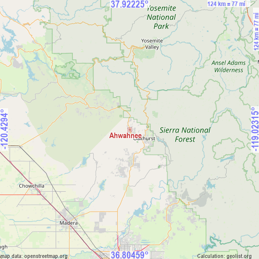
Ahwahnee GPS coordinates[2]
37° 21' 55.8" North, 119° 43' 34.572" West
| Map corner | latitude | longitude |
|---|---|---|
| Upper-left | 37.92225°, | -120.4294° |
| Center: | 37.3655°, | -119.72627° |
| Lower-right: | 36.80459°, | -119.02315° |
| Map W x H: | 124.3×124.3 km | = 77.2×77.2mi |
| max Lat: | 71.29058° ⇑64.6% North |
| Ahwahnee: | 37.3655° |
| min Lat: | ⇓35.4% South 19.06759° |
| min Long | Ahwahnee | max Long |
| -171.73463° | -119.72627° | -66.98998° |
| W 7.4%⇐ | ⇒92.6% E |
Elevation
Elevation of Ahwahnee is 720 m = 2362 ft, and this is 425.2 m = 1395 ft above average elevation for this country.
| Max E: |
3189 m = 10463 ft | 8.8% |
| Ahwahnee | 720 m 2362 ft | |
| Avg. | 294.8 m = 967 ft | |
Min E: |
-60 m = -197 ft | 91.2% |
See also: United States elevation on elevation.city.
Geographical zone
Ahwahnee is located in North temperate zone (between Tropic of Cancer and the Arctic Circle). Distance of this Northern Tropic circle is 1548.7 km =962.3 mi to South.| Distance of | km | miles | from Ahwahnee |
|---|---|---|---|
| North Pole | 5852.4 | 3636.5 | to North |
| Arctic Circle | 3246.5 | 2017.3 | to North |
| Tropic Cancer | 1548.7 | 962.3 | to South |
| Equator | 4154.7 | 2581.6 | to South |


Nearby cities:
15 places around Ahwahnee: (largest is in red/bold)
• Auberry
38.2 km =23.7 mi,  146°
146°
• Bass Lake
14.9 km =9.3 mi,  107°
107°
• Bonadelle Ranchos-Madera Ranchos
44.3 km =27.5 mi,  197°
197°
• Bootjack
18 km =11.2 mi,  307°
307°
• Catheys Valley
33.7 km =20.9 mi,  282°
282°
• Coarsegold
11.7 km =7.3 mi,  168°
168°
• Friant
42 km =26.1 mi,  178°
178°
• Le Grand
48.6 km =30.2 mi,  251°
251°
• Madera Acres
48.9 km =30.4 mi,  218°
218°
• Mariposa
25 km =15.5 mi,  302°
302°
• Midpines
26.3 km =16.3 mi,  319°
319°
• Oakhurst
8 km =5 mi,  121°
121°
• Shaver Lake
46.4 km =28.8 mi,  128°
128°
• Yosemite Lakes
19.8 km =12.3 mi,  191°
191°
• Yosemite Valley
43.7 km =27.2 mi,  17°
17°
Sources, notices
• [Note1] Compared only with cities in United States existing in our database
• [Src1] Map data: © OpenStreetMap contributors (CC-BY-SA)
• [Src2] Other city data from geonames.org with taken over terms of usage.
• [Src3] Geographical zone / Annual Mean Temperature by Robert A. Rohde @ Wikipedia
