Mariposa geodata
Mariposa (California) is a seat of a second-order administrative division; located in United States in America/Los_Angeles (GMT-7) time zone. With population of 2,173 people, there are 11411 cities with bigger population in this country. Compared to other cities in United States, 64.1% of cities are located further ↑North; 92.8% of cities are located further →East and 89.5% of cities have lower elevation than Mariposa. Note1


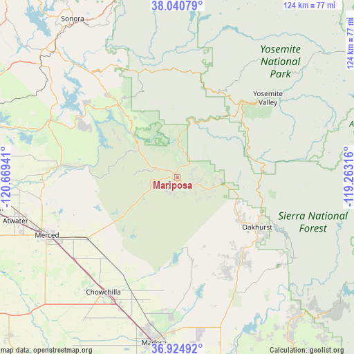
Mariposa GPS coordinates[2]
37° 29' 5.784" North, 119° 57' 58.608" West
| Map corner | latitude | longitude |
|---|---|---|
| Upper-left | 38.04079°, | -120.66941° |
| Center: | 37.48494°, | -119.96628° |
| Lower-right: | 36.92492°, | -119.26316° |
| Map W x H: | 124.1×124.1 km | = 77.1×77.1mi |
| max Lat: | 71.29058° ⇑64.1% North |
| Mariposa: | 37.48494° |
| min Lat: | ⇓35.9% South 19.06759° |
| min Long | Mariposa | max Long |
| -171.73463° | -119.96628° | -66.98998° |
| W 7.2%⇐ | ⇒92.8% E |
Elevation
Elevation of Mariposa is 590 m = 1936 ft, and this is 295.2 m = 969 ft above average elevation for this country.
| Max E: |
3189 m = 10463 ft | 10.5% |
| Mariposa | 590 m 1936 ft | |
| Avg. | 294.8 m = 967 ft | |
Min E: |
-60 m = -197 ft | 89.5% |
See also: United States elevation on elevation.city.
Geographical zone
Mariposa is located in North temperate zone (between Tropic of Cancer and the Arctic Circle). Distance of this Northern Tropic circle is 1562 km =970.6 mi to South.| Distance of | km | miles | from Mariposa |
|---|---|---|---|
| North Pole | 5839.1 | 3628.2 | to North |
| Arctic Circle | 3233.2 | 2009 | to North |
| Tropic Cancer | 1562 | 970.6 | to South |
| Equator | 4167.9 | 2589.8 | to South |


Nearby cities:
15 places around Mariposa: (largest is in red/bold)
• Ahwahnee
25 km =15.5 mi,  122°
122°
• Bass Lake
39.6 km =24.6 mi, 116°
• Bootjack
7.4 km =4.6 mi,  107°
107°
• Catheys Valley
13 km =8.1 mi,  243°
243°
• Chowchilla
47.9 km =29.8 mi,  212°
212°
• Coarsegold
34.1 km =21.2 mi,  136°
136°
• Fairmead
49.7 km =30.9 mi,  203°
203°
• Greeley Hill
32.3 km =20.1 mi,  333°
333°
• Groveland
45.8 km =28.5 mi, 329°
• Le Grand
37.9 km =23.5 mi,  221°
221°
• Midpines
7.7 km =4.8 mi,  31°
31°
• Oakhurst
33 km =20.5 mi, 121°
• Planada
37.9 km =23.5 mi, 235°
• Yosemite Lakes
36.9 km =22.9 mi,  152°
152°
• Yosemite Valley
44.5 km =27.7 mi,  50°
50°
Sources, notices
• [Note1] Compared only with cities in United States existing in our database
• [Src1] Map data: © OpenStreetMap contributors (CC-BY-SA)
• [Src2] Other city data from geonames.org with taken over terms of usage.
• [Src3] Geographical zone / Annual Mean Temperature by Robert A. Rohde @ Wikipedia
