Le Grand geodata
Le Grand (California) is a populated place; located in United States in America/Los_Angeles (GMT-7) time zone. With population of 1,659 people, there are 13052 cities with bigger population in this country. Compared to other cities in United States, 65.2% of cities are located further ↑North; 93.1% of cities are located further →East and 73.3% of cities have higher elevation than Le Grand. Note1


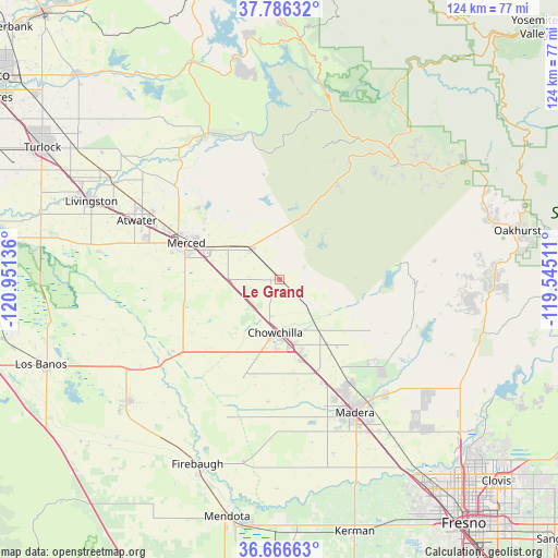
Le Grand GPS coordinates[2]
37° 13' 42.78" North, 120° 14' 53.628" West
| Map corner | latitude | longitude |
|---|---|---|
| Upper-left | 37.78632°, | -120.95136° |
| Center: | 37.22855°, | -120.24823° |
| Lower-right: | 36.66663°, | -119.54511° |
| Map W x H: | 124.5×124.5 km | = 77.4×77.4mi |
| max Lat: | 71.29058° ⇑65.2% North |
| Le Grand: | 37.22855° |
| min Lat: | ⇓34.8% South 19.06759° |
| min Long | Le Grand | max Long |
| -171.73463° | -120.24823° | -66.98998° |
| W 6.9%⇐ | ⇒93.1% E |
Elevation
Elevation of Le Grand is 81 m = 266 ft, and this is 213.8 m = 701 ft below average elevation for this country.
| Max E: |
3189 m = 10463 ft | 73.3% |
| Avg. | 294.8 m = 967 ft | |
| Le Grand | 81 m = 266 ft | |
Min E: |
-60 m = -197 ft | 26.7% |
See also: United States elevation on elevation.city.
Geographical zone
Le Grand is located in North temperate zone (between Tropic of Cancer and the Arctic Circle). Distance of this Northern Tropic circle is 1533.5 km =952.9 mi to South.| Distance of | km | miles | from Le Grand |
|---|---|---|---|
| North Pole | 5867.6 | 3646 | to North |
| Arctic Circle | 3261.7 | 2026.7 | to North |
| Tropic Cancer | 1533.5 | 952.9 | to South |
| Equator | 4139.4 | 2572.1 | to South |


Nearby cities:
15 places around Le Grand: (largest is in red/bold)
• Atwater
34.6 km =21.5 mi,  292°
292°
• Bonadelle Ranchos-Madera Ranchos
42.8 km =26.6 mi,  129°
129°
• Bootjack
41.4 km =25.7 mi,  50°
50°
• Catheys Valley
26.3 km =16.3 mi,  30°
30°
• Chowchilla
11.8 km =7.3 mi,  185°
185°
• Fairmead
17.6 km =10.9 mi,  163°
163°
• Madera
34 km =21.1 mi,  150°
150°
• Madera Acres
28.3 km =17.6 mi, 145°
• Mariposa
37.9 km =23.5 mi,  41°
41°
• Merced
22.3 km =13.9 mi, 291°
• Parksdale
37.1 km =23.1 mi, 147°
• Parkwood
38.1 km =23.7 mi, 151°
• Planada
9.3 km =5.8 mi,  318°
318°
• Winton
36.9 km =22.9 mi,  298°
298°
• Yosemite Lakes
42.3 km =26.3 mi,  95°
95°
Sources, notices
• [Note1] Compared only with cities in United States existing in our database
• [Src1] Map data: © OpenStreetMap contributors (CC-BY-SA)
• [Src2] Other city data from geonames.org with taken over terms of usage.
• [Src3] Geographical zone / Annual Mean Temperature by Robert A. Rohde @ Wikipedia
