Cherryland geodata
Cherryland (California) is a populated place; located in United States in America/Los_Angeles (GMT-7) time zone. With population of 14,728 people, there are 3289 cities with bigger population in this country. Compared to other cities in United States, 63.3% of cities are located further ↑North; 95.4% of cities are located further →East and 89.1% of cities have higher elevation than Cherryland. Note1


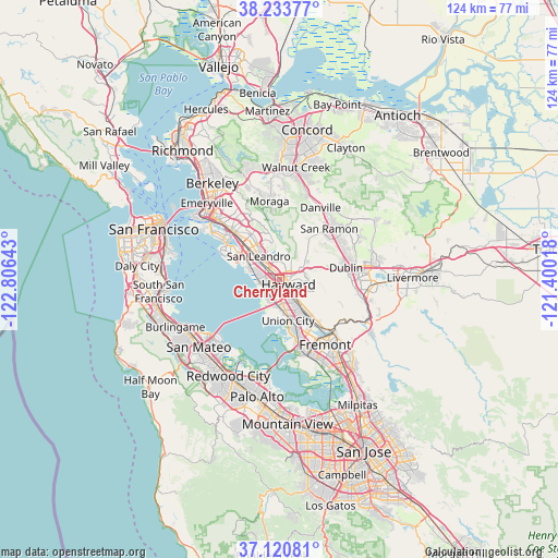
Cherryland GPS coordinates[2]
37° 40' 45.768" North, 122° 6' 11.88" West
| Map corner | latitude | longitude |
|---|---|---|
| Upper-left | 38.23377°, | -122.80643° |
| Center: | 37.67938°, | -122.1033° |
| Lower-right: | 37.12081°, | -121.40018° |
| Map W x H: | 123.7×123.7 km | = 76.9×76.9mi |
| max Lat: | 71.29058° ⇑63.3% North |
| Cherryland: | 37.67938° |
| min Lat: | ⇓36.7% South 19.06759° |
| min Long | Cherryland | max Long |
| -171.73463° | -122.1033° | -66.98998° |
| W 4.6%⇐ | ⇒95.4% E |
Elevation
Elevation of Cherryland is 18 m = 59 ft, and this is 276.8 m = 908 ft below average elevation for this country.
| Max E: |
3189 m = 10463 ft | 89.1% |
| Avg. | 294.8 m = 967 ft | |
| Cherryland | 18 m = 59 ft | |
Min E: |
-60 m = -197 ft | 10.9% |
See also: United States elevation on elevation.city.
Geographical zone
Cherryland is located in North temperate zone (between Tropic of Cancer and the Arctic Circle). Distance of this Northern Tropic circle is 1583.6 km =984 mi to South.| Distance of | km | miles | from Cherryland |
|---|---|---|---|
| North Pole | 5817.5 | 3614.8 | to North |
| Arctic Circle | 3211.6 | 1995.6 | to North |
| Tropic Cancer | 1583.6 | 984 | to South |
| Equator | 4189.6 | 2603.3 | to South |


Nearby cities:
15 places around Cherryland: (largest is in red/bold)
• Alameda
15.5 km =9.6 mi,  308°
308°
• Ashland
1.9 km =1.2 mi,  331°
331°
• Castro Valley
2.2 km =1.4 mi,  42°
42°
• Danville
18.2 km =11.3 mi,  29°
29°
• Dublin
15 km =9.3 mi,  80°
80°
• Fairview
5.1 km =3.2 mi,  91°
91°
• Fremont
17.7 km =11 mi,  145°
145°
• Hayward
2.3 km =1.4 mi,  120°
120°
• Moraga
17.5 km =10.9 mi,  352°
352°
• Newark
17.5 km =10.9 mi,  161°
161°
• Piedmont
19.7 km =12.2 mi, 325°
• San Leandro
6.9 km =4.3 mi,  317°
317°
• San Lorenzo
1.9 km =1.2 mi,  275°
275°
• San Ramon
15.7 km =9.8 mi, 44°
• Union City
11.9 km =7.4 mi,  141°
141°
Sources, notices
• [Note1] Compared only with cities in United States existing in our database
• [Src1] Map data: © OpenStreetMap contributors (CC-BY-SA)
• [Src2] Other city data from geonames.org with taken over terms of usage.
• [Src3] Geographical zone / Annual Mean Temperature by Robert A. Rohde @ Wikipedia
