Antelope geodata
Antelope (California) is a populated place; located in United States in America/Los_Angeles (GMT-7) time zone. With population of 45,770 people, there are 1047 cities with bigger population in this country. Compared to other cities in United States, 57.3% of cities are located further ↑North; 94.2% of cities are located further →East and 79.5% of cities have higher elevation than Antelope. Note1


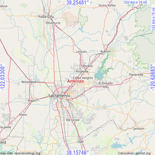
Antelope GPS coordinates[2]
38° 42' 29.664" North, 121° 19' 47.82" West
| Map corner | latitude | longitude |
|---|---|---|
| Upper-left | 39.25481°, | -122.03308° |
| Center: | 38.70824°, | -121.32995° |
| Lower-right: | 38.15746°, | -120.62683° |
| Map W x H: | 122×122 km | = 75.8×75.8mi |
| max Lat: | 71.29058° ⇑57.3% North |
| Antelope: | 38.70824° |
| min Lat: | ⇓42.7% South 19.06759° |
| min Long | Antelope | max Long |
| -171.73463° | -121.32995° | -66.98998° |
| W 5.8%⇐ | ⇒94.2% E |
Elevation
Elevation of Antelope is 49 m = 161 ft, and this is 245.8 m = 806 ft below average elevation for this country.
| Max E: |
3189 m = 10463 ft | 79.5% |
| Avg. | 294.8 m = 967 ft | |
| Antelope | 49 m = 161 ft | |
Min E: |
-60 m = -197 ft | 20.5% |
See also: Antelope elevation on elevation.city.
Geographical zone
Antelope is located in North temperate zone (between Tropic of Cancer and the Arctic Circle). Distance of this Northern Tropic circle is 1698 km =1055.1 mi to South.| Distance of | km | miles | from Antelope |
|---|---|---|---|
| North Pole | 5703.1 | 3543.7 | to North |
| Arctic Circle | 3097.2 | 1924.5 | to North |
| Tropic Cancer | 1698 | 1055.1 | to South |
| Equator | 4304 | 2674.4 | to South |


Nearby cities:
15 places around Antelope: (largest is in red/bold)
• Arden-Arcade
12.5 km =7.8 mi,  199°
199°
• Carmichael
10.1 km =6.3 mi,  179°
179°
• Citrus Heights
4.2 km =2.6 mi,  91°
91°
• Elverta
11.5 km =7.1 mi,  273°
273°
• Fair Oaks
8.7 km =5.4 mi,  144°
144°
• Folsom
13.8 km =8.6 mi,  104°
104°
• Foothill Farms
3.8 km =2.4 mi,  209°
209°
• Gold River
11.6 km =7.2 mi, 141°
• McClellan Park
8.1 km =5 mi,  230°
230°
• North Highlands
4.4 km =2.7 mi,  235°
235°
• Orangevale
9.6 km =6 mi,  110°
110°
• Rancho Cordova
13.5 km =8.4 mi,  169°
169°
• Rio Linda
10.5 km =6.5 mi,  259°
259°
• Rocklin
12.3 km =7.6 mi,  41°
41°
• Roseville
6.1 km =3.8 mi, 36°
Sources, notices
• [Note1] Compared only with cities in United States existing in our database
• [Src1] Map data: © OpenStreetMap contributors (CC-BY-SA)
• [Src2] Other city data from geonames.org with taken over terms of usage.
• [Src3] Geographical zone / Annual Mean Temperature by Robert A. Rohde @ Wikipedia
