Rocklin geodata
Rocklin (California) is a populated place; located in United States in America/Los_Angeles (GMT-7) time zone. With population of 61,213 people, there are 717 cities with bigger population in this country. Compared to other cities in United States, 56.6% of cities are located further ↑North; 94% of cities are located further →East and 74.2% of cities have higher elevation than Rocklin. Note1


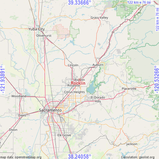
Rocklin GPS coordinates[2]
38° 47' 26.628" North, 121° 14' 8.808" West
| Map corner | latitude | longitude |
|---|---|---|
| Upper-left | 39.33666°, | -121.93891° |
| Center: | 38.79073°, | -121.23578° |
| Lower-right: | 38.24058°, | -120.53266° |
| Map W x H: | 121.9×121.9 km | = 75.7×75.7mi |
| max Lat: | 71.29058° ⇑56.6% North |
| Rocklin: | 38.79073° |
| min Lat: | ⇓43.4% South 19.06759° |
| min Long | Rocklin | max Long |
| -171.73463° | -121.23578° | -66.98998° |
| W 6%⇐ | ⇒94% E |
Elevation
Elevation of Rocklin is 76 m = 249 ft, and this is 218.8 m = 718 ft below average elevation for this country.
| Max E: |
3189 m = 10463 ft | 74.2% |
| Avg. | 294.8 m = 967 ft | |
| Rocklin | 76 m = 249 ft | |
Min E: |
-60 m = -197 ft | 25.8% |
See also: Rocklin elevation on elevation.city.
Geographical zone
Rocklin is located in North temperate zone (between Tropic of Cancer and the Arctic Circle). Distance of this Northern Tropic circle is 1707.2 km =1060.8 mi to South.| Distance of | km | miles | from Rocklin |
|---|---|---|---|
| North Pole | 5693.9 | 3538 | to North |
| Arctic Circle | 3088 | 1918.8 | to North |
| Tropic Cancer | 1707.2 | 1060.8 | to South |
| Equator | 4313.1 | 2680 | to South |


Nearby cities:
15 places around Rocklin: (largest is in red/bold)
• Antelope
12.3 km =7.6 mi,  221°
221°
• Auburn
18.1 km =11.2 mi,  49°
49°
• Citrus Heights
10.1 km =6.3 mi,  202°
202°
• El Dorado Hills
17.7 km =11 mi,  131°
131°
• Fair Oaks
16.5 km =10.3 mi,  190°
190°
• Folsom
13.6 km =8.5 mi,  157°
157°
• Foothill Farms
16 km =9.9 mi, 218°
• Granite Bay
6.9 km =4.3 mi,  116°
116°
• Lincoln
12.3 km =7.6 mi,  336°
336°
• Loomis
5 km =3.1 mi, 47°
• Newcastle
12.8 km =8 mi,  43°
43°
• North Highlands
16.6 km =10.3 mi,  225°
225°
• Orangevale
12.5 km =7.8 mi,  176°
176°
• Penryn
8.9 km =5.5 mi, 40°
• Roseville
6.2 km =3.9 mi, 226°
Sources, notices
• [Note1] Compared only with cities in United States existing in our database
• [Src1] Map data: © OpenStreetMap contributors (CC-BY-SA)
• [Src2] Other city data from geonames.org with taken over terms of usage.
• [Src3] Geographical zone / Annual Mean Temperature by Robert A. Rohde @ Wikipedia
