Roseville geodata
Roseville (California) is a populated place; located in United States in America/Los_Angeles (GMT-7) time zone. With population of 130,269 people, there are 234 cities with bigger population in this country. Compared to other cities in United States, 57% of cities are located further ↑North; 94.1% of cities are located further →East and 79% of cities have higher elevation than Roseville. Note1


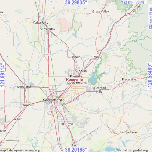
Roseville GPS coordinates[2]
38° 45' 7.632" North, 121° 17' 16.836" West
| Map corner | latitude | longitude |
|---|---|---|
| Upper-left | 39.29835°, | -121.99114° |
| Center: | 38.75212°, | -121.28801° |
| Lower-right: | 38.20168°, | -120.58489° |
| Map W x H: | 121.9×121.9 km | = 75.7×75.7mi |
| max Lat: | 71.29058° ⇑57% North |
| Roseville: | 38.75212° |
| min Lat: | ⇓43% South 19.06759° |
| min Long | Roseville | max Long |
| -171.73463° | -121.28801° | -66.98998° |
| W 5.9%⇐ | ⇒94.1% E |
Elevation
Elevation of Roseville is 51 m = 167 ft, and this is 243.8 m = 800 ft below average elevation for this country.
| Max E: |
3189 m = 10463 ft | 79% |
| Avg. | 294.8 m = 967 ft | |
| Roseville | 51 m = 167 ft | |
Min E: |
-60 m = -197 ft | 21% |
See also: Roseville elevation on elevation.city.
Geographical zone
Roseville is located in North temperate zone (between Tropic of Cancer and the Arctic Circle). Distance of this Northern Tropic circle is 1702.9 km =1058.1 mi to South.| Distance of | km | miles | from Roseville |
|---|---|---|---|
| North Pole | 5698.2 | 3540.7 | to North |
| Arctic Circle | 3092.3 | 1921.5 | to North |
| Tropic Cancer | 1702.9 | 1058.1 | to South |
| Equator | 4308.8 | 2677.4 | to South |


Nearby cities:
15 places around Roseville: (largest is in red/bold)
• Antelope
6.1 km =3.8 mi,  216°
216°
• Carmichael
15.4 km =9.6 mi,  193°
193°
• Citrus Heights
5 km =3.1 mi,  173°
173°
• Fair Oaks
12 km =7.5 mi, 173°
• Folsom
12.7 km =7.9 mi,  130°
130°
• Foothill Farms
9.8 km =6.1 mi,  213°
213°
• Gold River
14.4 km =8.9 mi, 165°
• Granite Bay
10.8 km =6.7 mi,  83°
83°
• Loomis
11.3 km =7 mi,  46°
46°
• McClellan Park
14 km =8.7 mi, 224°
• North Highlands
10.4 km =6.5 mi, 224°
• Orangevale
9.8 km =6.1 mi,  146°
146°
• Penryn
15.1 km =9.4 mi,  42°
42°
• Rio Linda
15.5 km =9.6 mi,  243°
243°
• Rocklin
6.2 km =3.9 mi, 46°
Sources, notices
• [Note1] Compared only with cities in United States existing in our database
• [Src1] Map data: © OpenStreetMap contributors (CC-BY-SA)
• [Src2] Other city data from geonames.org with taken over terms of usage.
• [Src3] Geographical zone / Annual Mean Temperature by Robert A. Rohde @ Wikipedia
