Antioch geodata
Antioch (California) is a populated place; located in United States in America/Los_Angeles (GMT-7) time zone. With population of 110,542 people, there are 300 cities with bigger population in this country. Compared to other cities in United States, 61.6% of cities are located further ↑North; 94.7% of cities are located further →East and 91.5% of cities have higher elevation than Antioch. Note1


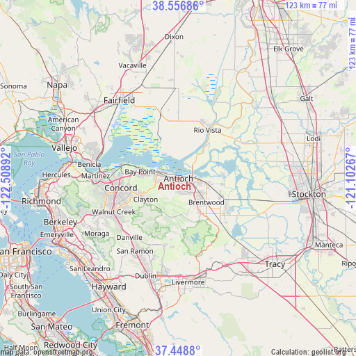
Antioch GPS coordinates[2]
38° 0' 17.712" North, 121° 48' 20.844" West
| Map corner | latitude | longitude |
|---|---|---|
| Upper-left | 38.55686°, | -122.50892° |
| Center: | 38.00492°, | -121.80579° |
| Lower-right: | 37.4488°, | -121.10267° |
| Map W x H: | 123.2×123.2 km | = 76.6×76.6mi |
| max Lat: | 71.29058° ⇑61.6% North |
| Antioch: | 38.00492° |
| min Lat: | ⇓38.4% South 19.06759° |
| min Long | Antioch | max Long |
| -171.73463° | -121.80579° | -66.98998° |
| W 5.3%⇐ | ⇒94.7% E |
Elevation
Elevation of Antioch is 13 m = 43 ft, and this is 281.8 m = 925 ft below average elevation for this country.
| Max E: |
3189 m = 10463 ft | 91.5% |
| Avg. | 294.8 m = 967 ft | |
| Antioch | 13 m = 43 ft | |
Min E: |
-60 m = -197 ft | 8.5% |
See also: Antioch elevation on elevation.city.
Geographical zone
Antioch is located in North temperate zone (between Tropic of Cancer and the Arctic Circle). Distance of this Northern Tropic circle is 1619.8 km =1006.5 mi to South.| Distance of | km | miles | from Antioch |
|---|---|---|---|
| North Pole | 5781.3 | 3592.3 | to North |
| Arctic Circle | 3175.4 | 1973.1 | to North |
| Tropic Cancer | 1619.8 | 1006.5 | to South |
| Equator | 4225.8 | 2625.8 | to South |


Nearby cities:
15 places around Antioch: (largest is in red/bold)
• Bay Point
13.9 km =8.6 mi,  281°
281°
• Bethel Island
14.5 km =9 mi,  85°
85°
• Blackhawk
22.3 km =13.9 mi,  203°
203°
• Brentwood
12.6 km =7.8 mi,  130°
130°
• Byron
21.2 km =13.2 mi,  136°
136°
• Clayton
13.4 km =8.3 mi,  238°
238°
• Clyde
19.7 km =12.2 mi, 276°
• Concord
20 km =12.4 mi,  261°
261°
• Diablo
23.1 km =14.4 mi,  215°
215°
• Discovery Bay
21 km =13 mi,  120°
120°
• Knightsen
12.7 km =7.9 mi,  108°
108°
• North Gate
20.1 km =12.5 mi, 236°
• Oakley
8.2 km =5.1 mi,  95°
95°
• Pittsburg
7.4 km =4.6 mi,  290°
290°
• Rio Vista
20.1 km =12.5 mi,  28°
28°
Sources, notices
• [Note1] Compared only with cities in United States existing in our database
• [Src1] Map data: © OpenStreetMap contributors (CC-BY-SA)
• [Src2] Other city data from geonames.org with taken over terms of usage.
• [Src3] Geographical zone / Annual Mean Temperature by Robert A. Rohde @ Wikipedia
