Pittsburg geodata
Pittsburg (California) is a populated place; located in United States in America/Los_Angeles (GMT-7) time zone. With population of 69,424 people, there are 599 cities with bigger population in this country. Compared to other cities in United States, 61.4% of cities are located further ↑North; 94.8% of cities are located further →East and 95.7% of cities have higher elevation than Pittsburg. Note1


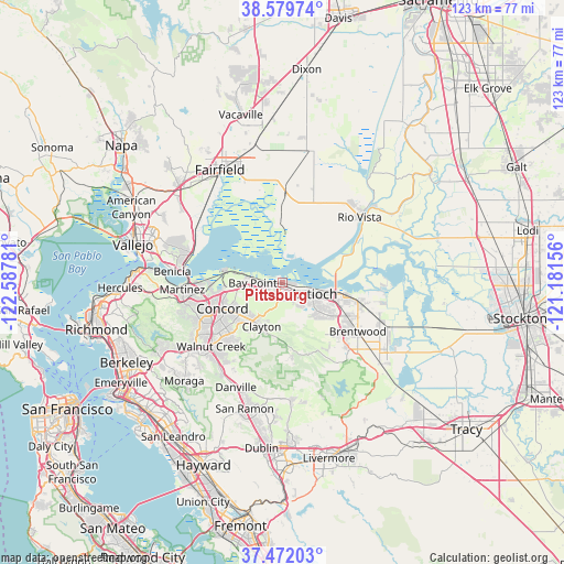
Pittsburg GPS coordinates[2]
38° 1' 40.728" North, 121° 53' 4.848" West
| Map corner | latitude | longitude |
|---|---|---|
| Upper-left | 38.57974°, | -122.58781° |
| Center: | 38.02798°, | -121.88468° |
| Lower-right: | 37.47203°, | -121.18156° |
| Map W x H: | 123.2×123.2 km | = 76.6×76.6mi |
| max Lat: | 71.29058° ⇑61.4% North |
| Pittsburg: | 38.02798° |
| min Lat: | ⇓38.6% South 19.06759° |
| min Long | Pittsburg | max Long |
| -171.73463° | -121.88468° | -66.98998° |
| W 5.2%⇐ | ⇒94.8% E |
Elevation
Elevation of Pittsburg is 8 m = 26 ft, and this is 286.8 m = 941 ft below average elevation for this country.
| Max E: |
3189 m = 10463 ft | 95.7% |
| Avg. | 294.8 m = 967 ft | |
| Pittsburg | 8 m = 26 ft | |
Min E: |
-60 m = -197 ft | 4.3% |
See also: Pittsburg elevation on elevation.city.
Geographical zone
Pittsburg is located in North temperate zone (between Tropic of Cancer and the Arctic Circle). Distance of this Northern Tropic circle is 1622.4 km =1008.1 mi to South.| Distance of | km | miles | from Pittsburg |
|---|---|---|---|
| North Pole | 5778.7 | 3590.7 | to North |
| Arctic Circle | 3172.9 | 1971.5 | to North |
| Tropic Cancer | 1622.4 | 1008.1 | to South |
| Equator | 4228.3 | 2627.3 | to South |


Nearby cities:
15 places around Pittsburg: (largest is in red/bold)
• Antioch
7.4 km =4.6 mi,  110°
110°
• Bay Point
6.7 km =4.2 mi,  271°
271°
• Brentwood
19.7 km =12.2 mi,  122°
122°
• Clayton
10.7 km =6.6 mi,  204°
204°
• Clyde
12.7 km =7.9 mi, 268°
• Concord
14 km =8.7 mi,  246°
246°
• Contra Costa Centre
18.8 km =11.7 mi,  233°
233°
• Knightsen
20.1 km =12.5 mi, 109°
• Mountain View
20.5 km =12.7 mi,  264°
264°
• North Gate
16.8 km =10.4 mi,  216°
216°
• Oakley
15.5 km =9.6 mi,  102°
102°
• Pacheco
17.4 km =10.8 mi, 253°
• Pleasant Hill
17.8 km =11.1 mi,  240°
240°
• Vine Hill
18.6 km =11.6 mi, 263°
• Waldon
18.8 km =11.7 mi, 232°
Sources, notices
• [Note1] Compared only with cities in United States existing in our database
• [Src1] Map data: © OpenStreetMap contributors (CC-BY-SA)
• [Src2] Other city data from geonames.org with taken over terms of usage.
• [Src3] Geographical zone / Annual Mean Temperature by Robert A. Rohde @ Wikipedia
