Oakley geodata
Oakley (California) is a populated place; located in United States in America/Los_Angeles (GMT-7) time zone. With population of 39,813 people, there are 1217 cities with bigger population in this country. Compared to other cities in United States, 61.6% of cities are located further ↑North; 94.6% of cities are located further →East and 98.1% of cities have higher elevation than Oakley. Note1


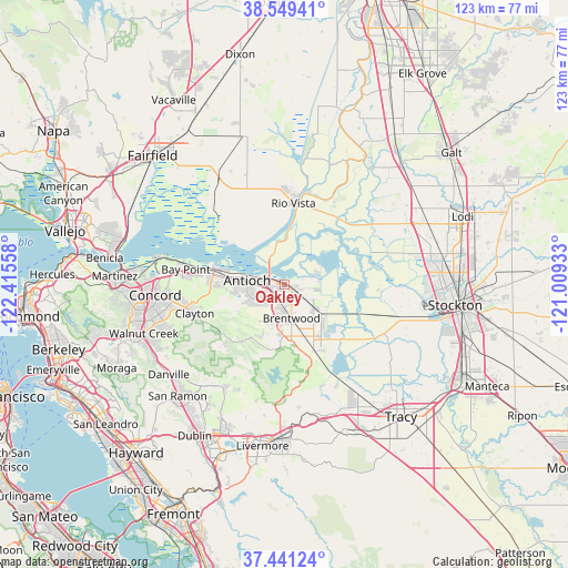
Oakley GPS coordinates[2]
37° 59' 50.712" North, 121° 42' 44.82" West
| Map corner | latitude | longitude |
|---|---|---|
| Upper-left | 38.54941°, | -122.41558° |
| Center: | 37.99742°, | -121.71245° |
| Lower-right: | 37.44124°, | -121.00933° |
| Map W x H: | 123.2×123.2 km | = 76.6×76.6mi |
| max Lat: | 71.29058° ⇑61.6% North |
| Oakley: | 37.99742° |
| min Lat: | ⇓38.4% South 19.06759° |
| min Long | Oakley | max Long |
| -171.73463° | -121.71245° | -66.98998° |
| W 5.4%⇐ | ⇒94.6% E |
Elevation
Elevation of Oakley is 5 m = 16 ft, and this is 289.8 m = 951 ft below average elevation for this country.
| Max E: |
3189 m = 10463 ft | 98.1% |
| Avg. | 294.8 m = 967 ft | |
| Oakley | 5 m = 16 ft | |
Min E: |
-60 m = -197 ft | 1.9% |
See also: United States elevation on elevation.city.
Geographical zone
Oakley is located in North temperate zone (between Tropic of Cancer and the Arctic Circle). Distance of this Northern Tropic circle is 1619 km =1006 mi to South.| Distance of | km | miles | from Oakley |
|---|---|---|---|
| North Pole | 5782.1 | 3592.8 | to North |
| Arctic Circle | 3176.3 | 1973.7 | to North |
| Tropic Cancer | 1619 | 1006 | to South |
| Equator | 4224.9 | 2625.2 | to South |


Nearby cities:
15 places around Oakley: (largest is in red/bold)
• Antioch
8.2 km =5.1 mi,  275°
275°
• Bay Point
22.1 km =13.7 mi, 279°
• Bethel Island
6.6 km =4.1 mi,  72°
72°
• Blackhawk
26.1 km =16.2 mi,  221°
221°
• Brentwood
7.4 km =4.6 mi,  168°
168°
• Byron
15.9 km =9.9 mi,  155°
155°
• Clayton
20.6 km =12.8 mi,  252°
252°
• Clyde
27.9 km =17.3 mi, 276°
• Concord
28 km =17.4 mi,  265°
265°
• Discovery Bay
13.9 km =8.6 mi,  135°
135°
• Isleton
20.3 km =12.6 mi,  25°
25°
• Knightsen
5 km =3.1 mi,  129°
129°
• North Gate
27 km =16.8 mi, 247°
• Pittsburg
15.5 km =9.6 mi, 282°
• Rio Vista
18.6 km =11.6 mi,  4°
4°
Sources, notices
• [Note1] Compared only with cities in United States existing in our database
• [Src1] Map data: © OpenStreetMap contributors (CC-BY-SA)
• [Src2] Other city data from geonames.org with taken over terms of usage.
• [Src3] Geographical zone / Annual Mean Temperature by Robert A. Rohde @ Wikipedia
