Armona geodata
Armona (California) is a populated place; located in United States in America/Los_Angeles (GMT-7) time zone. With population of 4,156 people, there are 8036 cities with bigger population in this country. Compared to other cities in United States, 68.8% of cities are located further ↑North; 92.6% of cities are located further →East and 74.6% of cities have higher elevation than Armona. Note1


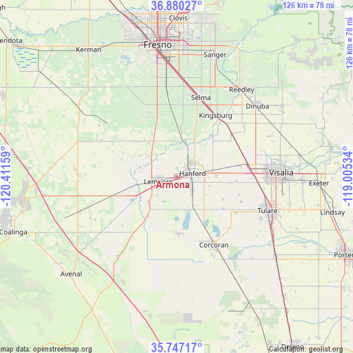
Armona GPS coordinates[2]
36° 18' 56.808" North, 119° 42' 30.456" West
| Map corner | latitude | longitude |
|---|---|---|
| Upper-left | 36.88027°, | -120.41159° |
| Center: | 36.31578°, | -119.70846° |
| Lower-right: | 35.74717°, | -119.00534° |
| Map W x H: | 126×126 km | = 78.3×78.3mi |
| max Lat: | 71.29058° ⇑68.8% North |
| Armona: | 36.31578° |
| min Lat: | ⇓31.2% South 19.06759° |
| min Long | Armona | max Long |
| -171.73463° | -119.70846° | -66.98998° |
| W 7.4%⇐ | ⇒92.6% E |
Elevation
Elevation of Armona is 74 m = 243 ft, and this is 220.8 m = 724 ft below average elevation for this country.
| Max E: |
3189 m = 10463 ft | 74.6% |
| Avg. | 294.8 m = 967 ft | |
| Armona | 74 m = 243 ft | |
Min E: |
-60 m = -197 ft | 25.4% |
See also: United States elevation on elevation.city.
Geographical zone
Armona is located in North temperate zone (between Tropic of Cancer and the Arctic Circle). Distance of this Northern Tropic circle is 1432 km =889.8 mi to South.| Distance of | km | miles | from Armona |
|---|---|---|---|
| North Pole | 5969.1 | 3709 | to North |
| Arctic Circle | 3363.2 | 2089.8 | to North |
| Tropic Cancer | 1432 | 889.8 | to South |
| Equator | 4037.9 | 2509 | to South |


Nearby cities:
15 places around Armona: (largest is in red/bold)
• Caruthers
27.6 km =17.1 mi,  336°
336°
• Corcoran
27.6 km =17.1 mi,  151°
151°
• Goshen
26.1 km =16.2 mi,  81°
81°
• Hanford
5.8 km =3.6 mi, 77°
• Home Garden
6.6 km =4.1 mi,  102°
102°
• Kingsburg
26 km =16.2 mi,  32°
32°
• Lanare
23.7 km =14.7 mi,  302°
302°
• Laton
13.2 km =8.2 mi,  8°
8°
• Lemoore
6.9 km =4.3 mi,  255°
255°
• Lemoore Station
18.5 km =11.5 mi,  251°
251°
• Lucerne
8.2 km =5.1 mi, 28°
• Riverdale
18.6 km =11.6 mi,  313°
313°
• Selma
29.6 km =18.4 mi,  16°
16°
• Stratford
17.4 km =10.8 mi,  216°
216°
• Traver
25.3 km =15.7 mi,  52°
52°
Sources, notices
• [Note1] Compared only with cities in United States existing in our database
• [Src1] Map data: © OpenStreetMap contributors (CC-BY-SA)
• [Src2] Other city data from geonames.org with taken over terms of usage.
• [Src3] Geographical zone / Annual Mean Temperature by Robert A. Rohde @ Wikipedia
