Selma geodata
Selma (California) is a populated place; located in United States in America/Los_Angeles (GMT-7) time zone. With population of 24,414 people, there are 2064 cities with bigger population in this country. Compared to other cities in United States, 67.8% of cities are located further ↑North; 92.5% of cities are located further →East and 70.1% of cities have higher elevation than Selma. Note1


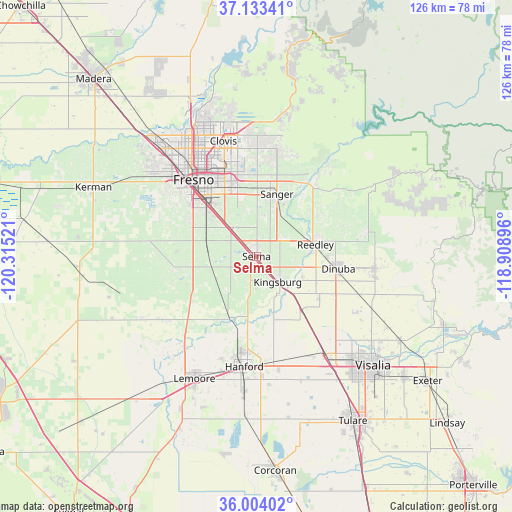
Selma GPS coordinates[2]
36° 34' 14.808" North, 119° 36' 43.488" West
| Map corner | latitude | longitude |
|---|---|---|
| Upper-left | 37.13341°, | -120.31521° |
| Center: | 36.57078°, | -119.61208° |
| Lower-right: | 36.00402°, | -118.90896° |
| Map W x H: | 125.6×125.6 km | = 78×78mi |
| max Lat: | 71.29058° ⇑67.8% North |
| Selma: | 36.57078° |
| min Lat: | ⇓32.2% South 19.06759° |
| min Long | Selma | max Long |
| -171.73463° | -119.61208° | -66.98998° |
| W 7.5%⇐ | ⇒92.5% E |
Elevation
Elevation of Selma is 100 m = 328 ft, and this is 194.8 m = 639 ft below average elevation for this country.
| Max E: |
3189 m = 10463 ft | 70.1% |
| Avg. | 294.8 m = 967 ft | |
| Selma | 100 m = 328 ft | |
Min E: |
-60 m = -197 ft | 29.9% |
See also: United States elevation on elevation.city.
Geographical zone
Selma is located in North temperate zone (between Tropic of Cancer and the Arctic Circle). Distance of this Northern Tropic circle is 1460.4 km =907.5 mi to South.| Distance of | km | miles | from Selma |
|---|---|---|---|
| North Pole | 5940.8 | 3691.4 | to North |
| Arctic Circle | 3334.9 | 2072.2 | to North |
| Tropic Cancer | 1460.4 | 907.5 | to South |
| Equator | 4066.3 | 2526.7 | to South |


Nearby cities:
15 places around Selma: (largest is in red/bold)
• Calwa
20.3 km =12.6 mi,  319°
319°
• Caruthers
20 km =12.4 mi,  261°
261°
• Del Rey
10 km =6.2 mi,  9°
9°
• Dinuba
20.3 km =12.6 mi,  98°
98°
• Easton
18.2 km =11.3 mi,  298°
298°
• Fowler
8.9 km =5.5 mi, 318°
• Kingsburg
8.2 km =5.1 mi,  140°
140°
• Laton
16.7 km =10.4 mi,  203°
203°
• London
18.4 km =11.4 mi,  124°
124°
• Malaga
16.6 km =10.3 mi, 319°
• Parlier
8.8 km =5.5 mi,  59°
59°
• Reedley
14.7 km =9.1 mi,  78°
78°
• Sanger
16.1 km =10 mi,  18°
18°
• Sunnyside
21.3 km =13.2 mi,  338°
338°
• Traver
17.2 km =10.7 mi, 138°
Sources, notices
• [Note1] Compared only with cities in United States existing in our database
• [Src1] Map data: © OpenStreetMap contributors (CC-BY-SA)
• [Src2] Other city data from geonames.org with taken over terms of usage.
• [Src3] Geographical zone / Annual Mean Temperature by Robert A. Rohde @ Wikipedia
