Caruthers geodata
Caruthers (California) is a populated place; located in United States in America/Los_Angeles (GMT-7) time zone. With population of 2,497 people, there are 10619 cities with bigger population in this country. Compared to other cities in United States, 67.9% of cities are located further ↑North; 92.7% of cities are located further →East and 73.9% of cities have higher elevation than Caruthers. Note1


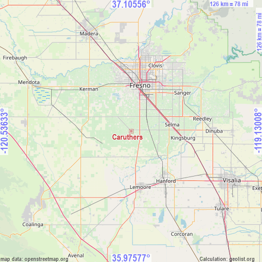
Caruthers GPS coordinates[2]
36° 32' 33.828" North, 119° 49' 59.52" West
| Map corner | latitude | longitude |
|---|---|---|
| Upper-left | 37.10556°, | -120.53633° |
| Center: | 36.54273°, | -119.8332° |
| Lower-right: | 35.97577°, | -119.13008° |
| Map W x H: | 125.6×125.6 km | = 78×78mi |
| max Lat: | 71.29058° ⇑67.9% North |
| Caruthers: | 36.54273° |
| min Lat: | ⇓32.1% South 19.06759° |
| min Long | Caruthers | max Long |
| -171.73463° | -119.8332° | -66.98998° |
| W 7.3%⇐ | ⇒92.7% E |
Elevation
Elevation of Caruthers is 78 m = 256 ft, and this is 216.8 m = 711 ft below average elevation for this country.
| Max E: |
3189 m = 10463 ft | 73.9% |
| Avg. | 294.8 m = 967 ft | |
| Caruthers | 78 m = 256 ft | |
Min E: |
-60 m = -197 ft | 26.1% |
See also: United States elevation on elevation.city.
Geographical zone
Caruthers is located in North temperate zone (between Tropic of Cancer and the Arctic Circle). Distance of this Northern Tropic circle is 1457.3 km =905.5 mi to South.| Distance of | km | miles | from Caruthers |
|---|---|---|---|
| North Pole | 5943.9 | 3693.4 | to North |
| Arctic Circle | 3338 | 2074.1 | to North |
| Tropic Cancer | 1457.3 | 905.5 | to South |
| Equator | 4063.2 | 2524.8 | to South |


Nearby cities:
15 places around Caruthers: (largest is in red/bold)
• Calwa
19.8 km =12.3 mi,  19°
19°
• Del Rey
25 km =15.5 mi,  58°
58°
• Easton
12.5 km =7.8 mi, 17°
• Fowler
16.9 km =10.5 mi,  54°
54°
• Fresno
23.4 km =14.5 mi,  13°
13°
• Kingsburg
25.2 km =15.7 mi,  97°
97°
• Lanare
15.2 km =9.4 mi,  215°
215°
• Laton
17.9 km =11.1 mi,  132°
132°
• Lemoore
27.3 km =17 mi,  170°
170°
• Lucerne
23.5 km =14.6 mi,  140°
140°
• Malaga
18 km =11.2 mi,  29°
29°
• Riverdale
12.6 km =7.8 mi,  190°
190°
• Selma
20 km =12.4 mi,  81°
81°
• Sunnyside
25.9 km =16.1 mi, 27°
• West Park
18.7 km =11.6 mi,  355°
355°
Sources, notices
• [Note1] Compared only with cities in United States existing in our database
• [Src1] Map data: © OpenStreetMap contributors (CC-BY-SA)
• [Src2] Other city data from geonames.org with taken over terms of usage.
• [Src3] Geographical zone / Annual Mean Temperature by Robert A. Rohde @ Wikipedia
