Hanford geodata
Hanford (California) is a seat of a second-order administrative division; located in United States in America/Los_Angeles (GMT-7) time zone. With population of 55,659 people, there are 822 cities with bigger population in this country. Compared to other cities in United States, 68.8% of cities are located further ↑North; 92.5% of cities are located further →East and 73.5% of cities have higher elevation than Hanford. Note1


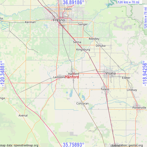
Hanford GPS coordinates[2]
36° 19' 38.82" North, 119° 38' 44.448" West
| Map corner | latitude | longitude |
|---|---|---|
| Upper-left | 36.89186°, | -120.34881° |
| Center: | 36.32745°, | -119.64568° |
| Lower-right: | 35.75893°, | -118.94256° |
| Map W x H: | 126×126 km | = 78.3×78.3mi |
| max Lat: | 71.29058° ⇑68.8% North |
| Hanford: | 36.32745° |
| min Lat: | ⇓31.2% South 19.06759° |
| min Long | Hanford | max Long |
| -171.73463° | -119.64568° | -66.98998° |
| W 7.5%⇐ | ⇒92.5% E |
Elevation
Elevation of Hanford is 80 m = 262 ft, and this is 214.8 m = 705 ft below average elevation for this country.
| Max E: |
3189 m = 10463 ft | 73.5% |
| Avg. | 294.8 m = 967 ft | |
| Hanford | 80 m = 262 ft | |
Min E: |
-60 m = -197 ft | 26.5% |
See also: Hanford elevation on elevation.city.
Geographical zone
Hanford is located in North temperate zone (between Tropic of Cancer and the Arctic Circle). Distance of this Northern Tropic circle is 1433.3 km =890.6 mi to South.| Distance of | km | miles | from Hanford |
|---|---|---|---|
| North Pole | 5967.8 | 3708.2 | to North |
| Arctic Circle | 3361.9 | 2089 | to North |
| Tropic Cancer | 1433.3 | 890.6 | to South |
| Equator | 4039.2 | 2509.8 | to South |


Nearby cities:
15 places around Hanford: (largest is in red/bold)
• Armona
5.8 km =3.6 mi,  257°
257°
• Corcoran
26.6 km =16.5 mi,  163°
163°
• Goshen
20.4 km =12.7 mi,  82°
82°
• Home Garden
2.8 km =1.7 mi, 162°
• Kingsburg
22.3 km =13.9 mi,  21°
21°
• Lanare
28 km =17.4 mi,  294°
294°
• Laton
12.3 km =7.6 mi,  342°
342°
• Lemoore
12.6 km =7.8 mi, 256°
• Lemoore Station
24.3 km =15.1 mi,  252°
252°
• London
24.5 km =15.2 mi,  47°
47°
• Lucerne
6.2 km =3.9 mi, 344°
• Riverdale
22.3 km =13.9 mi,  301°
301°
• Selma
27.2 km =16.9 mi,  6°
6°
• Stratford
22.1 km =13.7 mi,  226°
226°
• Traver
20.2 km =12.6 mi, 45°
Sources, notices
• [Note1] Compared only with cities in United States existing in our database
• [Src1] Map data: © OpenStreetMap contributors (CC-BY-SA)
• [Src2] Other city data from geonames.org with taken over terms of usage.
• [Src3] Geographical zone / Annual Mean Temperature by Robert A. Rohde @ Wikipedia
