Manteca geodata
Manteca (California) is a populated place; located in United States in America/Los_Angeles (GMT-7) time zone. With population of 75,448 people, there are 535 cities with bigger population in this country. Compared to other cities in United States, 62.7% of cities are located further ↑North; 94% of cities are located further →East and 91% of cities have higher elevation than Manteca. Note1


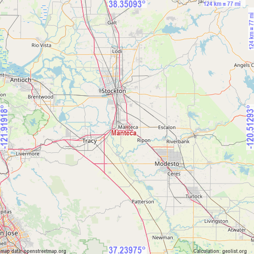
Manteca GPS coordinates[2]
37° 47' 50.748" North, 121° 12' 57.78" West
| Map corner | latitude | longitude |
|---|---|---|
| Upper-left | 38.35093°, | -121.91918° |
| Center: | 37.79743°, | -121.21605° |
| Lower-right: | 37.23975°, | -120.51293° |
| Map W x H: | 123.6×123.6 km | = 76.8×76.8mi |
| max Lat: | 71.29058° ⇑62.7% North |
| Manteca: | 37.79743° |
| min Lat: | ⇓37.3% South 19.06759° |
| min Long | Manteca | max Long |
| -171.73463° | -121.21605° | -66.98998° |
| W 6%⇐ | ⇒94% E |
Elevation
Elevation of Manteca is 14 m = 46 ft, and this is 280.8 m = 921 ft below average elevation for this country.
| Max E: |
3189 m = 10463 ft | 91% |
| Avg. | 294.8 m = 967 ft | |
| Manteca | 14 m = 46 ft | |
Min E: |
-60 m = -197 ft | 9% |
See also: Manteca elevation on elevation.city.
Geographical zone
Manteca is located in North temperate zone (between Tropic of Cancer and the Arctic Circle). Distance of this Northern Tropic circle is 1596.8 km =992.2 mi to South.| Distance of | km | miles | from Manteca |
|---|---|---|---|
| North Pole | 5804.4 | 3606.7 | to North |
| Arctic Circle | 3198.5 | 1987.5 | to North |
| Tropic Cancer | 1596.8 | 992.2 | to South |
| Equator | 4202.7 | 2611.4 | to South |


Nearby cities:
15 places around Manteca: (largest is in red/bold)
• August
20.6 km =12.8 mi,  348°
348°
• Country Club
22 km =13.7 mi,  330°
330°
• Del Rio
18.9 km =11.7 mi,  108°
108°
• Escalon
19.2 km =11.9 mi,  89°
89°
• French Camp
10.8 km =6.7 mi, 333°
• Garden Acres
18.5 km =11.5 mi,  356°
356°
• Kennedy
15.1 km =9.4 mi, 347°
• Lathrop
6 km =3.7 mi,  297°
297°
• Lincoln Village
25.1 km =15.6 mi,  336°
336°
• Peters
25.2 km =15.7 mi,  35°
35°
• Ripon
10.2 km =6.3 mi,  127°
127°
• Salida
15.4 km =9.6 mi, 131°
• Stockton
19 km =11.8 mi, 339°
• Taft Mosswood
14.2 km =8.8 mi, 335°
• Tracy
19.5 km =12.1 mi,  250°
250°
Sources, notices
• [Note1] Compared only with cities in United States existing in our database
• [Src1] Map data: © OpenStreetMap contributors (CC-BY-SA)
• [Src2] Other city data from geonames.org with taken over terms of usage.
• [Src3] Geographical zone / Annual Mean Temperature by Robert A. Rohde @ Wikipedia
