Blythe geodata
Blythe (California) is a populated place; located in United States in America/Los_Angeles (GMT-7) time zone. With population of 19,208 people, there are 2621 cities with bigger population in this country. Compared to other cities in United States, 82.6% of cities are located further ↑North; 88.8% of cities are located further →East and 73.2% of cities have higher elevation than Blythe. Note1


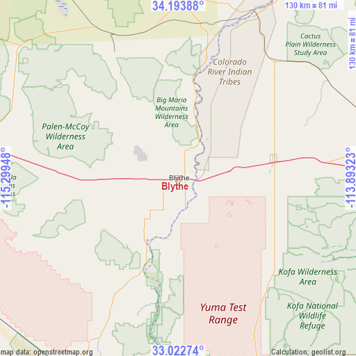
Blythe GPS coordinates[2]
33° 36' 37.08" North, 114° 35' 46.86" West
| Map corner | latitude | longitude |
|---|---|---|
| Upper-left | 34.19388°, | -115.29948° |
| Center: | 33.6103°, | -114.59635° |
| Lower-right: | 33.02274°, | -113.89323° |
| Map W x H: | 130.2×130.2 km | = 80.9×80.9mi |
| max Lat: | 71.29058° ⇑82.6% North |
| Blythe: | 33.6103° |
| min Lat: | ⇓17.4% South 19.06759° |
| min Long | Blythe | max Long |
| -171.73463° | -114.59635° | -66.98998° |
| W 11.2%⇐ | ⇒88.8% E |
Elevation
Elevation of Blythe is 82 m = 269 ft, and this is 212.8 m = 698 ft below average elevation for this country.
| Max E: |
3189 m = 10463 ft | 73.2% |
| Avg. | 294.8 m = 967 ft | |
| Blythe | 82 m = 269 ft | |
Min E: |
-60 m = -197 ft | 26.8% |
See also: United States elevation on elevation.city.
Geographical zone
Blythe is located in North temperate zone (between Tropic of Cancer and the Arctic Circle). Distance of this Northern Tropic circle is 1131.2 km =702.9 mi to South.| Distance of | km | miles | from Blythe |
|---|---|---|---|
| North Pole | 6269.9 | 3895.9 | to North |
| Arctic Circle | 3664.1 | 2276.8 | to North |
| Tropic Cancer | 1131.2 | 702.9 | to South |
| Equator | 3737.1 | 2322.1 | to South |


Nearby cities:
15 places around Blythe: (largest is in red/bold)
• Big River
62.8 km =39 mi,  20°
20°
• Bluewater
69.2 km =43 mi,  26°
26°
• Bouse
65.3 km =40.6 mi,  56°
56°
• Brenda
60.8 km =37.8 mi,  82°
82°
• Cienega Springs
72.9 km =45.3 mi, 28°
• Ehrenberg
6.6 km =4.1 mi,  95°
95°
• La Paz Valley
33 km =20.5 mi, 96°
• Mesa Verde
12.5 km =7.8 mi,  267°
267°
• Niland
95 km =59 mi,  244°
244°
• Parker
66.4 km =41.3 mi, 25°
• Parker Strip
77 km =47.8 mi, 28°
• Quartzsite
34.4 km =21.4 mi, 80°
• Ripley
11 km =6.8 mi,  210°
210°
• Salome
92.8 km =57.7 mi, 78°
• Vicksburg
79.5 km =49.4 mi, 79°
Sources, notices
• [Note1] Compared only with cities in United States existing in our database
• [Src1] Map data: © OpenStreetMap contributors (CC-BY-SA)
• [Src2] Other city data from geonames.org with taken over terms of usage.
• [Src3] Geographical zone / Annual Mean Temperature by Robert A. Rohde @ Wikipedia
