Niland geodata
Niland (California) is a populated place; located in United States in America/Los_Angeles (GMT-7) time zone. With population of 1,006 people, there are 16243 cities with bigger population in this country. Compared to other cities in United States, 84.2% of cities are located further ↑North; 89% of cities are located further →East and 100% of cities have higher elevation than Niland. Note1


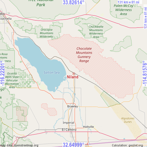
Niland GPS coordinates[2]
33° 14' 24.144" North, 115° 31' 7.968" West
| Map corner | latitude | longitude |
|---|---|---|
| Upper-left | 33.82614°, | -116.22201° |
| Center: | 33.24004°, | -115.51888° |
| Lower-right: | 32.64999°, | -114.81576° |
| Map W x H: | 130.8×130.8 km | = 81.3×81.3mi |
| max Lat: | 71.29058° ⇑84.2% North |
| Niland: | 33.24004° |
| min Lat: | ⇓15.8% South 19.06759° |
| min Long | Niland | max Long |
| -171.73463° | -115.51888° | -66.98998° |
| W 11%⇐ | ⇒89% E |
Elevation
Elevation of Niland is -42 m = -138 ft, and this is 336.8 m = 1105 ft below average elevation for this country.
| Max E: |
3189 m = 10463 ft | 100% |
| Avg. | 294.8 m = 967 ft | |
| Niland | -42 m = -138 ft | |
Min E: |
-60 m = -197 ft | 0% |
See also: United States elevation on elevation.city.
Geographical zone
Niland is located in North temperate zone (between Tropic of Cancer and the Arctic Circle). Distance of this Northern Tropic circle is 1090 km =677.3 mi to South.| Distance of | km | miles | from Niland |
|---|---|---|---|
| North Pole | 6311.1 | 3921.5 | to North |
| Arctic Circle | 3705.2 | 2302.3 | to North |
| Tropic Cancer | 1090 | 677.3 | to South |
| Equator | 3695.9 | 2296.5 | to South |


Nearby cities:
15 places around Niland: (largest is in red/bold)
• Brawley
29.1 km =18.1 mi,  182°
182°
• Calexico
62.4 km =38.8 mi, 178°
• Calipatria
12.7 km =7.9 mi, 178°
• Desert Shores
51.7 km =32.1 mi,  290°
290°
• El Centro
50 km =31.1 mi, 184°
• Heber
56.6 km =35.2 mi, 181°
• Holtville
49.4 km =30.7 mi,  164°
164°
• Imperial
43.9 km =27.3 mi,  186°
186°
• Mecca
63.7 km =39.6 mi,  305°
305°
• Oasis
59.4 km =36.9 mi, 294°
• Salton City
41.2 km =25.6 mi,  279°
279°
• Seeley
52.2 km =32.4 mi,  197°
197°
• Thermal
72.8 km =45.2 mi, 307°
• Vista Santa Rosa
77.9 km =48.4 mi,  303°
303°
• Westmorland
24.5 km =15.2 mi, 202°
Sources, notices
• [Note1] Compared only with cities in United States existing in our database
• [Src1] Map data: © OpenStreetMap contributors (CC-BY-SA)
• [Src2] Other city data from geonames.org with taken over terms of usage.
• [Src3] Geographical zone / Annual Mean Temperature by Robert A. Rohde @ Wikipedia
