Borrego Springs geodata
Borrego Springs (California) is a populated place; located in United States in America/Los_Angeles (GMT-7) time zone. With population of 3,429 people, there are 8942 cities with bigger population in this country. Compared to other cities in United States, 84.1% of cities are located further ↑North; 89.3% of cities are located further →East and 55.1% of cities have higher elevation than Borrego Springs. Note1


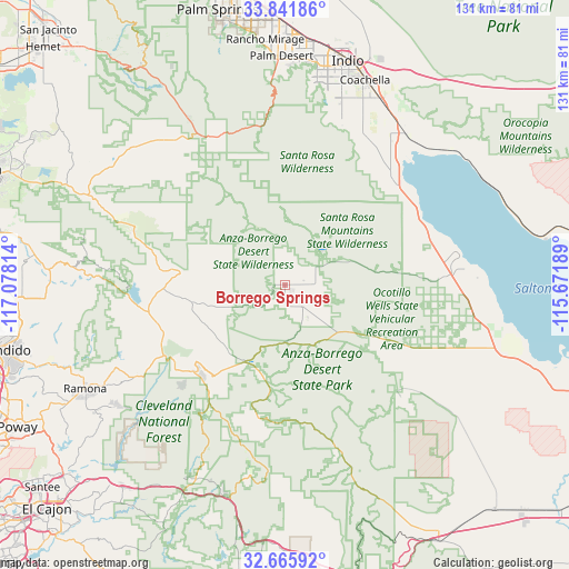
Borrego Springs GPS coordinates[2]
33° 15' 21.132" North, 116° 22' 30.036" West
| Map corner | latitude | longitude |
|---|---|---|
| Upper-left | 33.84186°, | -117.07814° |
| Center: | 33.25587°, | -116.37501° |
| Lower-right: | 32.66592°, | -115.67189° |
| Map W x H: | 130.8×130.8 km | = 81.3×81.3mi |
| max Lat: | 71.29058° ⇑84.1% North |
| Borrego Springs: | 33.25587° |
| min Lat: | ⇓15.9% South 19.06759° |
| min Long | Borrego Springs | max Long |
| -171.73463° | -116.37501° | -66.98998° |
| W 10.7%⇐ | ⇒89.3% E |
Elevation
Elevation of Borrego Springs is 180 m = 591 ft, and this is 114.8 m = 377 ft below average elevation for this country.
| Max E: |
3189 m = 10463 ft | 55.1% |
| Avg. | 294.8 m = 967 ft | |
| Borrego Springs | 180 m = 591 ft | |
Min E: |
-60 m = -197 ft | 44.9% |
See also: United States elevation on elevation.city.
Geographical zone
Borrego Springs is located in North temperate zone (between Tropic of Cancer and the Arctic Circle). Distance of this Northern Tropic circle is 1091.8 km =678.4 mi to South.| Distance of | km | miles | from Borrego Springs |
|---|---|---|---|
| North Pole | 6309.4 | 3920.5 | to North |
| Arctic Circle | 3703.5 | 2301.2 | to North |
| Tropic Cancer | 1091.8 | 678.4 | to South |
| Equator | 3697.7 | 2297.6 | to South |


Nearby cities:
15 places around Borrego Springs: (largest is in red/bold)
• Aguanga
50 km =31.1 mi,  294°
294°
• Anza
43.3 km =26.9 mi,  320°
320°
• Coachella
50.7 km =31.5 mi,  21°
21°
• Descanso
50.1 km =31.1 mi,  206°
206°
• Desert Shores
35.2 km =21.9 mi,  62°
62°
• Indian Wells
51.5 km =32 mi,  3°
3°
• Julian
28.9 km =18 mi,  226°
226°
• La Quinta
45.7 km =28.4 mi,  7°
7°
• Mecca
44.7 km =27.8 mi,  38°
38°
• Oasis
34.7 km =21.6 mi,  47°
47°
• Pine Valley
50.4 km =31.3 mi,  196°
196°
• Salton City
39.2 km =24.4 mi,  83°
83°
• San Diego Country Estates
47.1 km =29.3 mi, 233°
• Thermal
48 km =29.8 mi,  27°
27°
• Vista Santa Rosa
43.8 km =27.2 mi, 19°
Sources, notices
• [Note1] Compared only with cities in United States existing in our database
• [Src1] Map data: © OpenStreetMap contributors (CC-BY-SA)
• [Src2] Other city data from geonames.org with taken over terms of usage.
• [Src3] Geographical zone / Annual Mean Temperature by Robert A. Rohde @ Wikipedia
