San Diego Country Estates geodata
San Diego Country Estates (California) is a populated place; located in United States in America/Los_Angeles (GMT-7) time zone. With population of 10,109 people, there are 4430 cities with bigger population in this country. Compared to other cities in United States, 85.1% of cities are located further ↑North; 89.5% of cities are located further →East and 86.7% of cities have lower elevation than San Diego Country Estates. Note1
Current local time in San Diego Country Estates:
12:09 AM, WednesdayDifference from your time zone: hours


San Diego Country Estates GPS coordinates[2]
33° 0' 24.156" North, 116° 47' 1.104" West
| Map corner | latitude | longitude |
|---|---|---|
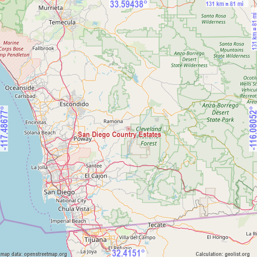
| Upper-left | 33.59438°, | -117.48677° |
| Center: | 33.00671°, | -116.78364° |
| Lower-right: | 32.4151°, | -116.08052° |
| Map W x H: | 131.1×131.1 km | = 81.5×81.5mi |
| max Lat: | 71.29058° ⇑85.1% North |
| San Diego Country Estates: | 33.00671° |
| min Lat: | ⇓14.9% South 19.06759° |
| min Long | San Diego Count | max Long |
| -171.73463° | -116.78364° | -66.98998° |
| W 10.5%⇐ | ⇒89.5% E |
Elevation
Elevation of San Diego Country Estates is 458 m = 1503 ft, and this is 163.2 m = 535 ft above average elevation for this country.
| Max E: |
3189 m = 10463 ft | 13.3% |
| San Diego Country Estates | 458 m 1503 ft | |
| Avg. | 294.8 m = 967 ft | |
Min E: |
-60 m = -197 ft | 86.7% |
See also: United States elevation on elevation.city.
Geographical zone
San Diego Country Estates is located in North temperate zone (between Tropic of Cancer and the Arctic Circle). Distance of this Northern Tropic circle is 1064.1 km =661.2 mi to South.| Distance of | km | miles | from San Diego Country Estates |
|---|---|---|---|
| North Pole | 6337.1 | 3937.7 | to North |
| Arctic Circle | 3731.2 | 2318.5 | to North |
| Tropic Cancer | 1064.1 | 661.2 | to South |
| Equator | 3670 | 2280.4 | to South |


Nearby cities:
15 places around San Diego Country Estates: (largest is in red/bold)
• Alpine
19.2 km =11.9 mi,  175°
175°
• Bostonia
26.3 km =16.3 mi,  212°
212°
• Crest
23.5 km =14.6 mi,  199°
199°
• Descanso
23.2 km =14.4 mi,  137°
137°
• Eucalyptus Hills
20.8 km =12.9 mi,  227°
227°
• Granite Hills
25.3 km =15.7 mi, 206°
• Harbison Canyon
21.2 km =13.2 mi,  191°
191°
• Hidden Trails
26.7 km =16.6 mi,  303°
303°
• Julian
18.7 km =11.6 mi,  64°
64°
• Lakeside
21.1 km =13.1 mi,  217°
217°
• Poway
24 km =14.9 mi,  258°
258°
• Ramona
8.8 km =5.5 mi, 296°
• San Pasqual
18.5 km =11.5 mi, 300°
• Santee
25.8 km =16 mi, 223°
• Winter Gardens
24 km =14.9 mi, 215°
Sources, notices
• [Note1] Compared only with cities in United States existing in our database
• [Src1] Map data: © OpenStreetMap contributors (CC-BY-SA)
• [Src2] Other city data from geonames.org with taken over terms of usage.
• [Src3] Geographical zone / Annual Mean Temperature by Robert A. Rohde @ Wikipedia
