Brea geodata
Brea (California) is a populated place; located in United States in America/Los_Angeles (GMT-7) time zone. With population of 41,944 people, there are 1143 cities with bigger population in this country. Compared to other cities in United States, 80.8% of cities are located further ↑North; 90.7% of cities are located further →East and 68% of cities have higher elevation than Brea. Note1


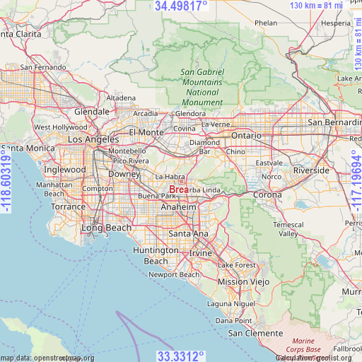
Brea GPS coordinates[2]
33° 55' 0.048" North, 117° 54' 0.216" West
| Map corner | latitude | longitude |
|---|---|---|
| Upper-left | 34.49817°, | -118.60319° |
| Center: | 33.91668°, | -117.90006° |
| Lower-right: | 33.3312°, | -117.19694° |
| Map W x H: | 129.8×129.8 km | = 80.7×80.7mi |
| max Lat: | 71.29058° ⇑80.8% North |
| Brea: | 33.91668° |
| min Lat: | ⇓19.2% South 19.06759° |
| min Long | Brea | max Long |
| -171.73463° | -117.90006° | -66.98998° |
| W 9.3%⇐ | ⇒90.7% E |
Elevation
Elevation of Brea is 112 m = 367 ft, and this is 182.8 m = 600 ft below average elevation for this country.
| Max E: |
3189 m = 10463 ft | 68% |
| Avg. | 294.8 m = 967 ft | |
| Brea | 112 m = 367 ft | |
Min E: |
-60 m = -197 ft | 32% |
See also: Brea elevation on elevation.city.
Geographical zone
Brea is located in North temperate zone (between Tropic of Cancer and the Arctic Circle). Distance of this Northern Tropic circle is 1165.3 km =724.1 mi to South.| Distance of | km | miles | from Brea |
|---|---|---|---|
| North Pole | 6235.9 | 3874.8 | to North |
| Arctic Circle | 3630 | 2255.6 | to North |
| Tropic Cancer | 1165.3 | 724.1 | to South |
| Equator | 3771.2 | 2343.3 | to South |


Nearby cities:
15 places around Brea: (largest is in red/bold)
• Anaheim
9.1 km =5.7 mi,  188°
188°
• Buena Park
10.6 km =6.6 mi,  238°
238°
• East La Mirada
8.2 km =5.1 mi,  276°
276°
• Fullerton
5.7 km =3.5 mi,  204°
204°
• Hacienda Heights
10.6 km =6.6 mi,  323°
323°
• La Habra
4.6 km =2.9 mi,  291°
291°
• La Habra Heights
6.8 km =4.2 mi, 316°
• La Mirada
10.3 km =6.4 mi,  270°
270°
• La Puente
12.4 km =7.7 mi,  338°
338°
• Placentia
5.7 km =3.5 mi,  150°
150°
• Rowland Heights
6.6 km =4.1 mi,  355°
355°
• South San Jose Hills
10.7 km =6.6 mi, 357°
• South Whittier
13.4 km =8.3 mi, 286°
• Walnut
12 km =7.5 mi,  15°
15°
• Yorba Linda
8.6 km =5.3 mi,  111°
111°
Sources, notices
• [Note1] Compared only with cities in United States existing in our database
• [Src1] Map data: © OpenStreetMap contributors (CC-BY-SA)
• [Src2] Other city data from geonames.org with taken over terms of usage.
• [Src3] Geographical zone / Annual Mean Temperature by Robert A. Rohde @ Wikipedia
