Fullerton geodata
Fullerton (California) is a populated place; located in United States in America/Los_Angeles (GMT-7) time zone. With population of 140,847 people, there are 212 cities with bigger population in this country. Compared to other cities in United States, 81.2% of cities are located further ↑North; 90.8% of cities are located further →East and 78.8% of cities have higher elevation than Fullerton. Note1


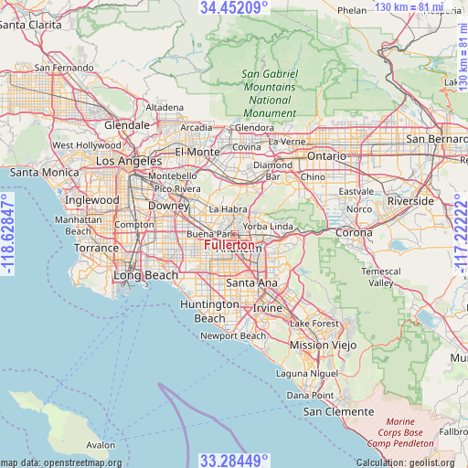
Fullerton GPS coordinates[2]
33° 52' 13.044" North, 117° 55' 31.224" West
| Map corner | latitude | longitude |
|---|---|---|
| Upper-left | 34.45209°, | -118.62847° |
| Center: | 33.87029°, | -117.92534° |
| Lower-right: | 33.28449°, | -117.22222° |
| Map W x H: | 129.8×129.8 km | = 80.7×80.7mi |
| max Lat: | 71.29058° ⇑81.2% North |
| Fullerton: | 33.87029° |
| min Lat: | ⇓18.8% South 19.06759° |
| min Long | Fullerton | max Long |
| -171.73463° | -117.92534° | -66.98998° |
| W 9.2%⇐ | ⇒90.8% E |
Elevation
Elevation of Fullerton is 52 m = 171 ft, and this is 242.8 m = 797 ft below average elevation for this country.
| Max E: |
3189 m = 10463 ft | 78.8% |
| Avg. | 294.8 m = 967 ft | |
| Fullerton | 52 m = 171 ft | |
Min E: |
-60 m = -197 ft | 21.2% |
See also: Fullerton elevation on elevation.city.
Geographical zone
Fullerton is located in North temperate zone (between Tropic of Cancer and the Arctic Circle). Distance of this Northern Tropic circle is 1160.1 km =720.9 mi to South.| Distance of | km | miles | from Fullerton |
|---|---|---|---|
| North Pole | 6241 | 3878 | to North |
| Arctic Circle | 3635.2 | 2258.8 | to North |
| Tropic Cancer | 1160.1 | 720.9 | to South |
| Equator | 3766 | 2340.1 | to South |


Nearby cities:
15 places around Fullerton: (largest is in red/bold)
• Anaheim
4 km =2.5 mi,  165°
165°
• Brea
5.7 km =3.5 mi,  24°
24°
• Buena Park
6.7 km =4.2 mi,  267°
267°
• Cypress
11.9 km =7.4 mi,  240°
240°
• East La Mirada
8.4 km =5.2 mi,  315°
315°
• Garden Grove
10.8 km =6.7 mi,  187°
187°
• La Habra
7.1 km =4.4 mi,  344°
344°
• La Habra Heights
10.3 km =6.4 mi,  346°
346°
• La Mirada
9.6 km =6 mi,  303°
303°
• La Palma
11.5 km =7.1 mi,  256°
256°
• Orange
11.3 km =7 mi,  143°
143°
• Placentia
5.1 km =3.2 mi,  87°
87°
• Rowland Heights
11.9 km =7.4 mi,  8°
8°
• Stanton
9.8 km =6.1 mi,  219°
219°
• Yorba Linda
10.6 km =6.6 mi,  78°
78°
Sources, notices
• [Note1] Compared only with cities in United States existing in our database
• [Src1] Map data: © OpenStreetMap contributors (CC-BY-SA)
• [Src2] Other city data from geonames.org with taken over terms of usage.
• [Src3] Geographical zone / Annual Mean Temperature by Robert A. Rohde @ Wikipedia
