Yorba Linda geodata
Yorba Linda (California) is a populated place; located in United States in America/Los_Angeles (GMT-7) time zone. With population of 67,973 people, there are 615 cities with bigger population in this country. Compared to other cities in United States, 81% of cities are located further ↑North; 90.6% of cities are located further →East and 67.3% of cities have higher elevation than Yorba Linda. Note1


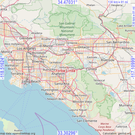
Yorba Linda GPS coordinates[2]
33° 53' 19.068" North, 117° 48' 47.196" West
| Map corner | latitude | longitude |
|---|---|---|
| Upper-left | 34.47031°, | -118.51624° |
| Center: | 33.88863°, | -117.81311° |
| Lower-right: | 33.30296°, | -117.10999° |
| Map W x H: | 129.8×129.8 km | = 80.7×80.7mi |
| max Lat: | 71.29058° ⇑81% North |
| Yorba Linda: | 33.88863° |
| min Lat: | ⇓19% South 19.06759° |
| min Long | Yorba Linda | max Long |
| -171.73463° | -117.81311° | -66.98998° |
| W 9.4%⇐ | ⇒90.6% E |
Elevation
Elevation of Yorba Linda is 116 m = 381 ft, and this is 178.8 m = 587 ft below average elevation for this country.
| Max E: |
3189 m = 10463 ft | 67.3% |
| Avg. | 294.8 m = 967 ft | |
| Yorba Linda | 116 m = 381 ft | |
Min E: |
-60 m = -197 ft | 32.7% |
See also: Yorba Linda elevation on elevation.city.
Geographical zone
Yorba Linda is located in North temperate zone (between Tropic of Cancer and the Arctic Circle). Distance of this Northern Tropic circle is 1162.1 km =722.1 mi to South.| Distance of | km | miles | from Yorba Linda |
|---|---|---|---|
| North Pole | 6239 | 3876.7 | to North |
| Arctic Circle | 3633.1 | 2257.5 | to North |
| Tropic Cancer | 1162.1 | 722.1 | to South |
| Equator | 3768.1 | 2341.4 | to South |


Nearby cities:
15 places around Yorba Linda: (largest is in red/bold)
• Anaheim
11.1 km =6.9 mi,  237°
237°
• Brea
8.6 km =5.3 mi,  291°
291°
• Chino Hills
12.7 km =7.9 mi,  23°
23°
• Diamond Bar
15.6 km =9.7 mi,  0°
0°
• Fullerton
10.6 km =6.6 mi,  258°
258°
• La Habra
13.2 km =8.2 mi, 291°
• La Habra Heights
15 km =9.3 mi,  302°
302°
• Los Serranos
13.5 km =8.4 mi,  45°
45°
• North Tustin
13.9 km =8.6 mi,  172°
172°
• Orange
11.8 km =7.3 mi,  198°
198°
• Placentia
5.6 km =3.5 mi,  250°
250°
• Rowland Heights
12.9 km =8 mi,  318°
318°
• Tustin
15.9 km =9.9 mi,  184°
184°
• Villa Park
8.2 km =5.1 mi, 180°
• Walnut
15.4 km =9.6 mi,  341°
341°
Sources, notices
• [Note1] Compared only with cities in United States existing in our database
• [Src1] Map data: © OpenStreetMap contributors (CC-BY-SA)
• [Src2] Other city data from geonames.org with taken over terms of usage.
• [Src3] Geographical zone / Annual Mean Temperature by Robert A. Rohde @ Wikipedia
