Carson geodata
Carson (California) is a populated place; located in United States in America/Los_Angeles (GMT-7) time zone. With population of 93,281 people, there are 391 cities with bigger population in this country. Compared to other cities in United States, 81.4% of cities are located further ↑North; 91.3% of cities are located further →East and 90% of cities have higher elevation than Carson. Note1


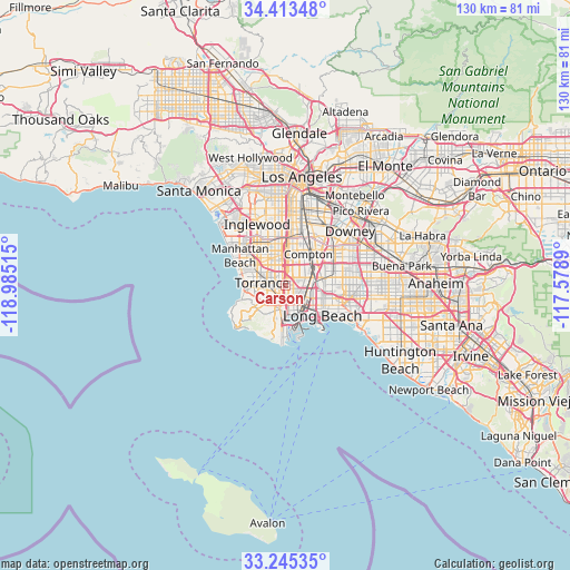
Carson GPS coordinates[2]
33° 49' 53.076" North, 118° 16' 55.272" West
| Map corner | latitude | longitude |
|---|---|---|
| Upper-left | 34.41348°, | -118.98515° |
| Center: | 33.83141°, | -118.28202° |
| Lower-right: | 33.24535°, | -117.5789° |
| Map W x H: | 129.9×129.9 km | = 80.7×80.7mi |
| max Lat: | 71.29058° ⇑81.4% North |
| Carson: | 33.83141° |
| min Lat: | ⇓18.6% South 19.06759° |
| min Long | Carson | max Long |
| -171.73463° | -118.28202° | -66.98998° |
| W 8.7%⇐ | ⇒91.3% E |
Elevation
Elevation of Carson is 16 m = 52 ft, and this is 278.8 m = 915 ft below average elevation for this country.
| Max E: |
3189 m = 10463 ft | 90% |
| Avg. | 294.8 m = 967 ft | |
| Carson | 16 m = 52 ft | |
Min E: |
-60 m = -197 ft | 10% |
See also: Carson elevation on elevation.city.
Geographical zone
Carson is located in North temperate zone (between Tropic of Cancer and the Arctic Circle). Distance of this Northern Tropic circle is 1155.8 km =718.2 mi to South.| Distance of | km | miles | from Carson |
|---|---|---|---|
| North Pole | 6245.4 | 3880.7 | to North |
| Arctic Circle | 3639.5 | 2261.5 | to North |
| Tropic Cancer | 1155.8 | 718.2 | to South |
| Equator | 3761.7 | 2337.4 | to South |


Nearby cities:
15 places around Carson: (largest is in red/bold)
• Alondra Park
7.9 km =4.9 mi,  325°
325°
• Compton
9.2 km =5.7 mi,  38°
38°
• Gardena
6.8 km =4.2 mi,  338°
338°
• Lawndale
9 km =5.6 mi,  313°
313°
• Lomita
5.3 km =3.3 mi,  215°
215°
• Palos Verdes Estates
10.7 km =6.6 mi,  251°
251°
• Redondo Beach
10 km =6.2 mi,  281°
281°
• Rolling Hills
10.8 km =6.7 mi, 220°
• Rolling Hills Estates
8.5 km =5.3 mi,  235°
235°
• San Pedro
10.7 km =6.6 mi,  185°
185°
• Torrance
5.4 km =3.4 mi, 275°
• West Athens
10.4 km =6.5 mi,  349°
349°
• West Carson
1.5 km =0.9 mi, 222°
• West Rancho Dominguez
7 km =4.3 mi,  8°
8°
• Willowbrook
9.8 km =6.1 mi, 14°
Sources, notices
• [Note1] Compared only with cities in United States existing in our database
• [Src1] Map data: © OpenStreetMap contributors (CC-BY-SA)
• [Src2] Other city data from geonames.org with taken over terms of usage.
• [Src3] Geographical zone / Annual Mean Temperature by Robert A. Rohde @ Wikipedia
