Gardena geodata
Gardena (California) is a populated place; located in United States in America/Los_Angeles (GMT-7) time zone. With population of 60,447 people, there are 737 cities with bigger population in this country. Compared to other cities in United States, 81% of cities are located further ↑North; 91.3% of cities are located further →East and 89.1% of cities have higher elevation than Gardena. Note1


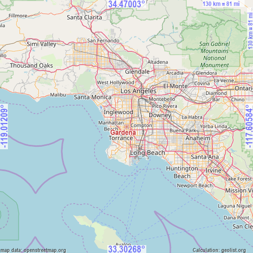
Gardena GPS coordinates[2]
33° 53' 18.06" North, 118° 18' 32.256" West
| Map corner | latitude | longitude |
|---|---|---|
| Upper-left | 34.47003°, | -119.01209° |
| Center: | 33.88835°, | -118.30896° |
| Lower-right: | 33.30268°, | -117.60584° |
| Map W x H: | 129.8×129.8 km | = 80.7×80.7mi |
| max Lat: | 71.29058° ⇑81% North |
| Gardena: | 33.88835° |
| min Lat: | ⇓19% South 19.06759° |
| min Long | Gardena | max Long |
| -171.73463° | -118.30896° | -66.98998° |
| W 8.7%⇐ | ⇒91.3% E |
Elevation
Elevation of Gardena is 18 m = 59 ft, and this is 276.8 m = 908 ft below average elevation for this country.
| Max E: |
3189 m = 10463 ft | 89.1% |
| Avg. | 294.8 m = 967 ft | |
| Gardena | 18 m = 59 ft | |
Min E: |
-60 m = -197 ft | 10.9% |
See also: Gardena elevation on elevation.city.
Geographical zone
Gardena is located in North temperate zone (between Tropic of Cancer and the Arctic Circle). Distance of this Northern Tropic circle is 1162.1 km =722.1 mi to South.| Distance of | km | miles | from Gardena |
|---|---|---|---|
| North Pole | 6239 | 3876.7 | to North |
| Arctic Circle | 3633.1 | 2257.5 | to North |
| Tropic Cancer | 1162.1 | 722.1 | to South |
| Equator | 3768 | 2341.3 | to South |


Nearby cities:
15 places around Gardena: (largest is in red/bold)
• Alondra Park
2 km =1.2 mi,  273°
273°
• Carson
6.8 km =4.2 mi,  158°
158°
• Compton
8.2 km =5.1 mi,  84°
84°
• Del Aire
6.4 km =4 mi,  298°
298°
• Hawthorne
5.1 km =3.2 mi,  307°
307°
• Hermosa Beach
8.8 km =5.5 mi,  250°
250°
• Lawndale
4 km =2.5 mi, 268°
• Lennox
6.8 km =4.2 mi,  323°
323°
• Redondo Beach
8.5 km =5.3 mi,  239°
239°
• Torrance
6.5 km =4 mi,  206°
206°
• West Athens
3.9 km =2.4 mi,  7°
7°
• West Carson
7.6 km =4.7 mi,  168°
168°
• West Rancho Dominguez
3.6 km =2.2 mi, 80°
• Westmont
5.9 km =3.7 mi, 5°
• Willowbrook
5.9 km =3.7 mi,  57°
57°
Sources, notices
• [Note1] Compared only with cities in United States existing in our database
• [Src1] Map data: © OpenStreetMap contributors (CC-BY-SA)
• [Src2] Other city data from geonames.org with taken over terms of usage.
• [Src3] Geographical zone / Annual Mean Temperature by Robert A. Rohde @ Wikipedia
