Torrance geodata
Torrance (California) is a populated place; located in United States in America/Los_Angeles (GMT-7) time zone. With population of 148,475 people, there are 197 cities with bigger population in this country. Compared to other cities in United States, 81.3% of cities are located further ↑North; 91.4% of cities are located further →East and 83.6% of cities have higher elevation than Torrance. Note1


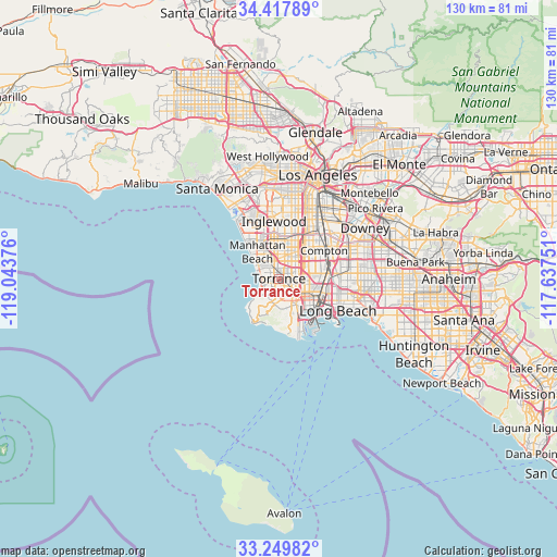
Torrance GPS coordinates[2]
33° 50' 9.06" North, 118° 20' 26.268" West
| Map corner | latitude | longitude |
|---|---|---|
| Upper-left | 34.41789°, | -119.04376° |
| Center: | 33.83585°, | -118.34063° |
| Lower-right: | 33.24982°, | -117.63751° |
| Map W x H: | 129.9×129.9 km | = 80.7×80.7mi |
| max Lat: | 71.29058° ⇑81.3% North |
| Torrance: | 33.83585° |
| min Lat: | ⇓18.7% South 19.06759° |
| min Long | Torrance | max Long |
| -171.73463° | -118.34063° | -66.98998° |
| W 8.6%⇐ | ⇒91.4% E |
Elevation
Elevation of Torrance is 33 m = 108 ft, and this is 261.8 m = 859 ft below average elevation for this country.
| Max E: |
3189 m = 10463 ft | 83.6% |
| Avg. | 294.8 m = 967 ft | |
| Torrance | 33 m = 108 ft | |
Min E: |
-60 m = -197 ft | 16.4% |
See also: Torrance elevation on elevation.city.
Geographical zone
Torrance is located in North temperate zone (between Tropic of Cancer and the Arctic Circle). Distance of this Northern Tropic circle is 1156.3 km =718.5 mi to South.| Distance of | km | miles | from Torrance |
|---|---|---|---|
| North Pole | 6244.9 | 3880.4 | to North |
| Arctic Circle | 3639 | 2261.2 | to North |
| Tropic Cancer | 1156.3 | 718.5 | to South |
| Equator | 3762.2 | 2337.7 | to South |


Nearby cities:
15 places around Torrance: (largest is in red/bold)
• Alondra Park
6 km =3.7 mi,  8°
8°
• Carson
5.4 km =3.4 mi,  95°
95°
• Del Aire
9.3 km =5.8 mi,  343°
343°
• Gardena
6.5 km =4 mi,  26°
26°
• Hawthorne
9 km =5.6 mi,  352°
352°
• Hermosa Beach
6.2 km =3.9 mi,  298°
298°
• Lawndale
5.8 km =3.6 mi, 349°
• Lomita
5.4 km =3.4 mi,  154°
154°
• Manhattan Beach
8.5 km =5.3 mi,  309°
309°
• Palos Verdes Estates
6.2 km =3.9 mi,  231°
231°
• Redondo Beach
4.7 km =2.9 mi,  288°
288°
• Rolling Hills
8.9 km =5.5 mi,  190°
190°
• Rolling Hills Estates
5.6 km =3.5 mi,  196°
196°
• West Carson
4.7 km =2.9 mi,  109°
109°
• West Rancho Dominguez
9.1 km =5.7 mi,  45°
45°
Sources, notices
• [Note1] Compared only with cities in United States existing in our database
• [Src1] Map data: © OpenStreetMap contributors (CC-BY-SA)
• [Src2] Other city data from geonames.org with taken over terms of usage.
• [Src3] Geographical zone / Annual Mean Temperature by Robert A. Rohde @ Wikipedia
