Lakewood geodata
Lakewood (California) is a populated place; located in United States in America/Los_Angeles (GMT-7) time zone. With population of 81,611 people, there are 481 cities with bigger population in this country. Compared to other cities in United States, 81.2% of cities are located further ↑North; 91.1% of cities are located further →East and 88.2% of cities have higher elevation than Lakewood. Note1


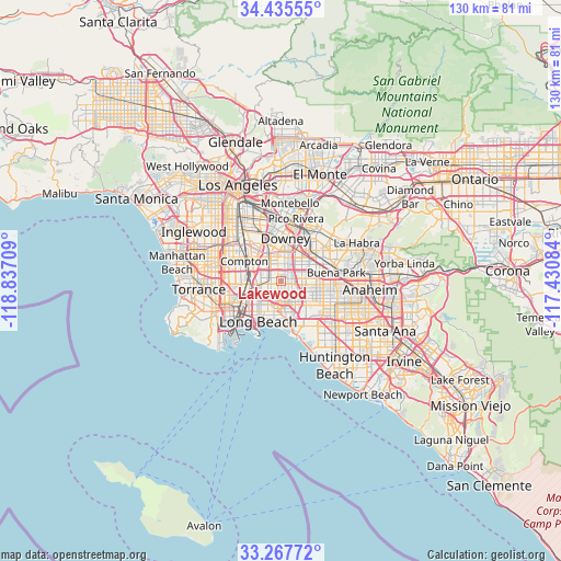
Lakewood GPS coordinates[2]
33° 51' 13.068" North, 118° 8' 2.256" West
| Map corner | latitude | longitude |
|---|---|---|
| Upper-left | 34.43555°, | -118.83709° |
| Center: | 33.85363°, | -118.13396° |
| Lower-right: | 33.26772°, | -117.43084° |
| Map W x H: | 129.9×129.9 km | = 80.7×80.7mi |
| max Lat: | 71.29058° ⇑81.2% North |
| Lakewood: | 33.85363° |
| min Lat: | ⇓18.8% South 19.06759° |
| min Long | Lakewood | max Long |
| -171.73463° | -118.13396° | -66.98998° |
| W 8.9%⇐ | ⇒91.1% E |
Elevation
Elevation of Lakewood is 20 m = 66 ft, and this is 274.8 m = 902 ft below average elevation for this country.
| Max E: |
3189 m = 10463 ft | 88.2% |
| Avg. | 294.8 m = 967 ft | |
| Lakewood | 20 m = 66 ft | |
Min E: |
-60 m = -197 ft | 11.8% |
See also: Lakewood elevation on elevation.city.
Geographical zone
Lakewood is located in North temperate zone (between Tropic of Cancer and the Arctic Circle). Distance of this Northern Tropic circle is 1158.3 km =719.7 mi to South.| Distance of | km | miles | from Lakewood |
|---|---|---|---|
| North Pole | 6242.9 | 3879.2 | to North |
| Arctic Circle | 3637 | 2259.9 | to North |
| Tropic Cancer | 1158.3 | 719.7 | to South |
| Equator | 3764.2 | 2339 | to South |


Nearby cities:
15 places around Lakewood: (largest is in red/bold)
• Artesia
4.9 km =3 mi,  73°
73°
• Bellflower
3.5 km =2.2 mi,  26°
26°
• Cerritos
6.4 km =4 mi,  85°
85°
• Compton
9.2 km =5.7 mi,  300°
300°
• Cypress
9.8 km =6.1 mi,  114°
114°
• Downey
9.6 km =6 mi,  0°
0°
• East Rancho Dominguez
7.5 km =4.7 mi,  311°
311°
• Hawaiian Gardens
6.2 km =3.9 mi, 113°
• La Palma
8.1 km =5 mi,  95°
95°
• Long Beach
10.9 km =6.8 mi,  207°
207°
• Los Alamitos
8 km =5 mi,  134°
134°
• Norwalk
7.2 km =4.5 mi,  41°
41°
• Paramount
4.6 km =2.9 mi,  329°
329°
• Rossmoor
8.8 km =5.5 mi,  149°
149°
• Signal Hill
6.3 km =3.9 mi, 209°
Sources, notices
• [Note1] Compared only with cities in United States existing in our database
• [Src1] Map data: © OpenStreetMap contributors (CC-BY-SA)
• [Src2] Other city data from geonames.org with taken over terms of usage.
• [Src3] Geographical zone / Annual Mean Temperature by Robert A. Rohde @ Wikipedia
