Norwalk geodata
Norwalk (California) is a populated place; located in United States in America/Los_Angeles (GMT-7) time zone. With population of 107,140 people, there are 320 cities with bigger population in this country. Compared to other cities in United States, 80.9% of cities are located further ↑North; 91% of cities are located further →East and 84.8% of cities have higher elevation than Norwalk. Note1


Norwalk GPS coordinates[2]
33° 54' 8.064" North, 118° 4' 54.228" West
| Map corner | latitude | longitude |
|---|---|---|
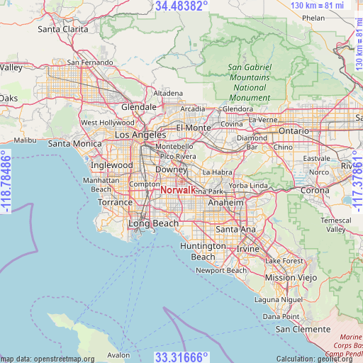
| Upper-left | 34.48382°, | -118.78486° |
| Center: | 33.90224°, | -118.08173° |
| Lower-right: | 33.31666°, | -117.37861° |
| Map W x H: | 129.8×129.8 km | = 80.7×80.7mi |
| max Lat: | 71.29058° ⇑80.9% North |
| Norwalk: | 33.90224° |
| min Lat: | ⇓19.1% South 19.06759° |
| min Long | Norwalk | max Long |
| -171.73463° | -118.08173° | -66.98998° |
| W 9%⇐ | ⇒91% E |
Elevation
Elevation of Norwalk is 29 m = 95 ft, and this is 265.8 m = 872 ft below average elevation for this country.
| Max E: |
3189 m = 10463 ft | 84.8% |
| Avg. | 294.8 m = 967 ft | |
| Norwalk | 29 m = 95 ft | |
Min E: |
-60 m = -197 ft | 15.2% |
See also: Norwalk elevation on elevation.city.
Geographical zone
Norwalk is located in North temperate zone (between Tropic of Cancer and the Arctic Circle). Distance of this Northern Tropic circle is 1163.7 km =723.1 mi to South.| Distance of | km | miles | from Norwalk |
|---|---|---|---|
| North Pole | 6237.5 | 3875.8 | to North |
| Arctic Circle | 3631.6 | 2256.6 | to North |
| Tropic Cancer | 1163.7 | 723.1 | to South |
| Equator | 3769.6 | 2342.3 | to South |


Nearby cities:
15 places around Norwalk: (largest is in red/bold)
• Artesia
4 km =2.5 mi,  181°
181°
• Bellflower
4 km =2.5 mi,  234°
234°
• Buena Park
8.6 km =5.3 mi,  116°
116°
• Cerritos
5.1 km =3.2 mi,  162°
162°
• Downey
6.3 km =3.9 mi,  311°
311°
• East La Mirada
8.9 km =5.5 mi,  73°
73°
• Hawaiian Gardens
7.9 km =4.9 mi,  174°
174°
• La Mirada
6.6 km =4.1 mi,  75°
75°
• La Palma
7 km =4.3 mi,  152°
152°
• Lakewood
7.2 km =4.5 mi,  221°
221°
• Paramount
7.3 km =4.5 mi,  258°
258°
• Pico Rivera
9.1 km =5.7 mi,  351°
351°
• Santa Fe Springs
5 km =3.1 mi,  356°
356°
• South Whittier
6.6 km =4.1 mi,  36°
36°
• West Whittier-Los Nietos
8.3 km =5.2 mi,  8°
8°
Sources, notices
• [Note1] Compared only with cities in United States existing in our database
• [Src1] Map data: © OpenStreetMap contributors (CC-BY-SA)
• [Src2] Other city data from geonames.org with taken over terms of usage.
• [Src3] Geographical zone / Annual Mean Temperature by Robert A. Rohde @ Wikipedia
