Newark geodata
Newark (California) is a section of populated place; located in United States in America/Los_Angeles (GMT-7) time zone. With population of 45,336 people, there are 1054 cities with bigger population in this country. Compared to other cities in United States, 64% of cities are located further ↑North; 95.2% of cities are located further →East and 98.1% of cities have higher elevation than Newark. Note1


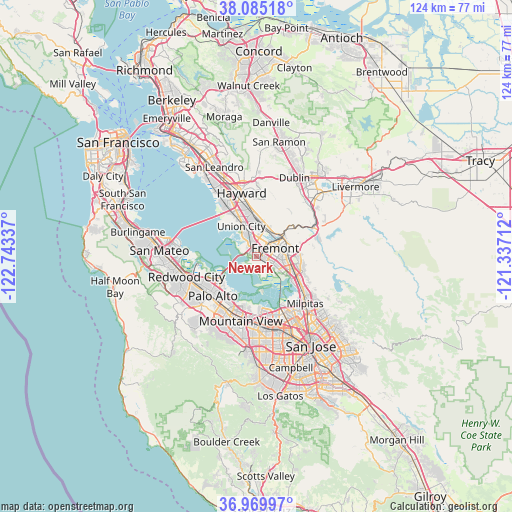
Newark GPS coordinates[2]
37° 31' 46.776" North, 122° 2' 24.864" West
| Map corner | latitude | longitude |
|---|---|---|
| Upper-left | 38.08518°, | -122.74337° |
| Center: | 37.52966°, | -122.04024° |
| Lower-right: | 36.96997°, | -121.33712° |
| Map W x H: | 124×124 km | = 77.1×77.1mi |
| max Lat: | 71.29058° ⇑64% North |
| Newark: | 37.52966° |
| min Lat: | ⇓36% South 19.06759° |
| min Long | Newark | max Long |
| -171.73463° | -122.04024° | -66.98998° |
| W 4.8%⇐ | ⇒95.2% E |
Elevation
Elevation of Newark is 5 m = 16 ft, and this is 289.8 m = 951 ft below average elevation for this country.
| Max E: |
3189 m = 10463 ft | 98.1% |
| Avg. | 294.8 m = 967 ft | |
| Newark | 5 m = 16 ft | |
Min E: |
-60 m = -197 ft | 1.9% |
See also: Newark elevation on elevation.city.
Geographical zone
Newark is located in North temperate zone (between Tropic of Cancer and the Arctic Circle). Distance of this Northern Tropic circle is 1567 km =973.7 mi to South.| Distance of | km | miles | from Newark |
|---|---|---|---|
| North Pole | 5834.2 | 3625.2 | to North |
| Arctic Circle | 3228.3 | 2006 | to North |
| Tropic Cancer | 1567 | 973.7 | to South |
| Equator | 4172.9 | 2592.9 | to South |


Nearby cities:
15 places around Newark: (largest is in red/bold)
• Atherton
15.8 km =9.8 mi,  241°
241°
• Cherryland
17.5 km =10.9 mi,  341°
341°
• East Palo Alto
11.2 km =7 mi,  232°
232°
• Fairview
16.6 km =10.3 mi,  358°
358°
• Fremont
5 km =3.1 mi,  65°
65°
• Hayward
15.9 km =9.9 mi,  346°
346°
• Los Altos
17.3 km =10.7 mi,  202°
202°
• Menlo Park
15.1 km =9.4 mi, 236°
• Milpitas
16.3 km =10.1 mi,  133°
133°
• Mountain View
16.4 km =10.2 mi,  193°
193°
• North Fair Oaks
15.1 km =9.4 mi,  245°
245°
• Palo Alto
13.3 km =8.3 mi,  222°
222°
• Stanford
16.2 km =10.1 mi, 223°
• Sunol
15.2 km =9.4 mi,  61°
61°
• Union City
7.6 km =4.7 mi,  14°
14°
Sources, notices
• [Note1] Compared only with cities in United States existing in our database
• [Src1] Map data: © OpenStreetMap contributors (CC-BY-SA)
• [Src2] Other city data from geonames.org with taken over terms of usage.
• [Src3] Geographical zone / Annual Mean Temperature by Robert A. Rohde @ Wikipedia
