Chico geodata
Chico (California) is a populated place; located in United States in America/Los_Angeles (GMT-7) time zone. With population of 90,316 people, there are 408 cities with bigger population in this country. Compared to other cities in United States, 50.9% of cities are located further ↓South; 94.7% of cities are located further →East and 76.3% of cities have higher elevation than Chico. Note1


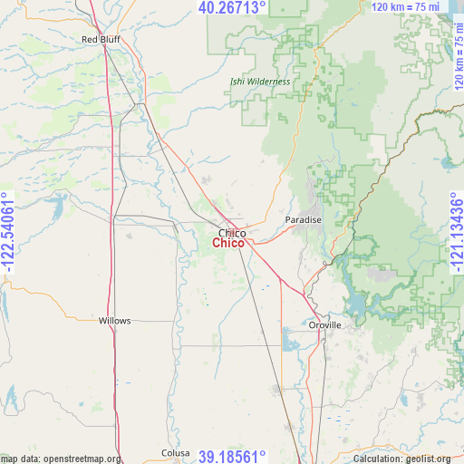
Chico GPS coordinates[2]
39° 43' 42.564" North, 121° 50' 14.928" West
| Map corner | latitude | longitude |
|---|---|---|
| Upper-left | 40.26713°, | -122.54061° |
| Center: | 39.72849°, | -121.83748° |
| Lower-right: | 39.18561°, | -121.13436° |
| Map W x H: | 120.3×120.3 km | = 74.8×74.8mi |
| max Lat: | 71.29058° ⇑49.1% North |
| Chico: | 39.72849° |
| min Lat: | ⇓50.9% South 19.06759° |
| min Long | Chico | max Long |
| -171.73463° | -121.83748° | -66.98998° |
| W 5.3%⇐ | ⇒94.7% E |
Elevation
Elevation of Chico is 64 m = 210 ft, and this is 230.8 m = 757 ft below average elevation for this country.
| Max E: |
3189 m = 10463 ft | 76.3% |
| Avg. | 294.8 m = 967 ft | |
| Chico | 64 m = 210 ft | |
Min E: |
-60 m = -197 ft | 23.7% |
See also: Chico elevation on elevation.city.
Geographical zone
Chico is located in North temperate zone (between Tropic of Cancer and the Arctic Circle). Distance of this Northern Tropic circle is 1811.5 km =1125.6 mi to South.| Distance of | km | miles | from Chico |
|---|---|---|---|
| North Pole | 5589.7 | 3473.3 | to North |
| Arctic Circle | 2983.8 | 1854 | to North |
| Tropic Cancer | 1811.5 | 1125.6 | to South |
| Equator | 4417.4 | 2744.8 | to South |


Nearby cities:
15 places around Chico: (largest is in red/bold)
• Berry Creek
38.3 km =23.8 mi,  104°
104°
• Biggs
36.7 km =22.8 mi,  163°
163°
• Cohasset
23.7 km =14.7 mi,  22°
22°
• Concow
26.6 km =16.5 mi,  89°
89°
• Corning
36.6 km =22.7 mi,  307°
307°
• Durham
9.7 km =6 mi, 160°
• Forest Ranch
22.1 km =13.7 mi,  39°
39°
• Hamilton City
15.1 km =9.4 mi,  275°
275°
• Magalia
24 km =14.9 mi,  67°
67°
• Orland
30.8 km =19.1 mi,  273°
273°
• Oroville
33.8 km =21 mi,  134°
134°
• Paradise
18.8 km =11.7 mi,  79°
79°
• South Oroville
35.5 km =22.1 mi,  136°
136°
• Thermalito
32.3 km =20.1 mi, 138°
• Willows
38 km =23.6 mi,  233°
233°
Sources, notices
• [Note1] Compared only with cities in United States existing in our database
• [Src1] Map data: © OpenStreetMap contributors (CC-BY-SA)
• [Src2] Other city data from geonames.org with taken over terms of usage.
• [Src3] Geographical zone / Annual Mean Temperature by Robert A. Rohde @ Wikipedia
