Durham geodata
Durham (California) is a populated place; located in United States in America/Los_Angeles (GMT-7) time zone. With population of 5,518 people, there are 6743 cities with bigger population in this country. Compared to other cities in United States, 50.3% of cities are located further ↓South; 94.7% of cities are located further →East and 79.9% of cities have higher elevation than Durham. Note1


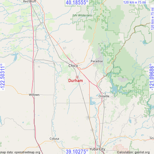
Durham GPS coordinates[2]
39° 38' 46.572" North, 121° 47' 59.928" West
| Map corner | latitude | longitude |
|---|---|---|
| Upper-left | 40.18555°, | -122.50311° |
| Center: | 39.64627°, | -121.79998° |
| Lower-right: | 39.10275°, | -121.09686° |
| Map W x H: | 120.4×120.4 km | = 74.8×74.8mi |
| max Lat: | 71.29058° ⇑49.7% North |
| Durham: | 39.64627° |
| min Lat: | ⇓50.3% South 19.06759° |
| min Long | Durham | max Long |
| -171.73463° | -121.79998° | -66.98998° |
| W 5.3%⇐ | ⇒94.7% E |
Elevation
Elevation of Durham is 47 m = 154 ft, and this is 247.8 m = 813 ft below average elevation for this country.
| Max E: |
3189 m = 10463 ft | 79.9% |
| Avg. | 294.8 m = 967 ft | |
| Durham | 47 m = 154 ft | |
Min E: |
-60 m = -197 ft | 20.1% |
See also: United States elevation on elevation.city.
Geographical zone
Durham is located in North temperate zone (between Tropic of Cancer and the Arctic Circle). Distance of this Northern Tropic circle is 1802.3 km =1119.9 mi to South.| Distance of | km | miles | from Durham |
|---|---|---|---|
| North Pole | 5598.8 | 3478.9 | to North |
| Arctic Circle | 2992.9 | 1859.7 | to North |
| Tropic Cancer | 1802.3 | 1119.9 | to South |
| Equator | 4408.3 | 2739.2 | to South |


Nearby cities:
15 places around Durham: (largest is in red/bold)
• Berry Creek
34 km =21.1 mi,  90°
90°
• Biggs
27.1 km =16.8 mi,  163°
163°
• Chico
9.7 km =6 mi,  340°
340°
• Cohasset
31.6 km =19.6 mi,  10°
10°
• Concow
25.2 km =15.7 mi,  68°
68°
• Forest Ranch
28.4 km =17.6 mi,  22°
22°
• Gridley
32.7 km =20.3 mi, 163°
• Hamilton City
21.2 km =13.2 mi,  300°
300°
• Magalia
26.4 km =16.4 mi,  45°
45°
• Oroville
25.4 km =15.8 mi,  125°
125°
• Oroville East
31.6 km =19.6 mi,  118°
118°
• Palermo
32.5 km =20.2 mi,  136°
136°
• Paradise
19.8 km =12.3 mi, 50°
• South Oroville
27 km =16.8 mi, 128°
• Thermalito
23.6 km =14.7 mi, 129°
Sources, notices
• [Note1] Compared only with cities in United States existing in our database
• [Src1] Map data: © OpenStreetMap contributors (CC-BY-SA)
• [Src2] Other city data from geonames.org with taken over terms of usage.
• [Src3] Geographical zone / Annual Mean Temperature by Robert A. Rohde @ Wikipedia
