Orland geodata
Orland (California) is a populated place; located in United States in America/Los_Angeles (GMT-7) time zone. With population of 7,550 people, there are 5512 cities with bigger population in this country. Compared to other cities in United States, 51.1% of cities are located further ↓South; 95.6% of cities are located further →East and 73.5% of cities have higher elevation than Orland. Note1


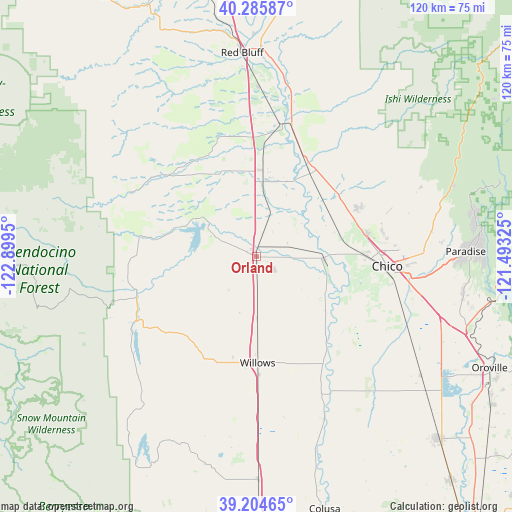
Orland GPS coordinates[2]
39° 44' 50.568" North, 122° 11' 46.932" West
| Map corner | latitude | longitude |
|---|---|---|
| Upper-left | 40.28587°, | -122.8995° |
| Center: | 39.74738°, | -122.19637° |
| Lower-right: | 39.20465°, | -121.49325° |
| Map W x H: | 120.2×120.2 km | = 74.7×74.7mi |
| max Lat: | 71.29058° ⇑48.9% North |
| Orland: | 39.74738° |
| min Lat: | ⇓51.1% South 19.06759° |
| min Long | Orland | max Long |
| -171.73463° | -122.19637° | -66.98998° |
| W 4.4%⇐ | ⇒95.6% E |
Elevation
Elevation of Orland is 80 m = 262 ft, and this is 214.8 m = 705 ft below average elevation for this country.
| Max E: |
3189 m = 10463 ft | 73.5% |
| Avg. | 294.8 m = 967 ft | |
| Orland | 80 m = 262 ft | |
Min E: |
-60 m = -197 ft | 26.5% |
See also: United States elevation on elevation.city.
Geographical zone
Orland is located in North temperate zone (between Tropic of Cancer and the Arctic Circle). Distance of this Northern Tropic circle is 1813.6 km =1126.9 mi to South.| Distance of | km | miles | from Orland |
|---|---|---|---|
| North Pole | 5587.6 | 3472 | to North |
| Arctic Circle | 2981.7 | 1852.7 | to North |
| Tropic Cancer | 1813.6 | 1126.9 | to South |
| Equator | 4419.5 | 2746.1 | to South |


Nearby cities:
15 places around Orland: (largest is in red/bold)
• Biggs
55.7 km =34.6 mi,  131°
131°
• Chico
30.8 km =19.1 mi,  93°
93°
• Cohasset
44.4 km =27.6 mi,  63°
63°
• Corning
20.1 km =12.5 mi,  4°
4°
• Durham
35.7 km =22.2 mi,  108°
108°
• Forest Ranch
47.2 km =29.3 mi,  71°
71°
• Gerber
34.6 km =21.5 mi,  6°
6°
• Hamilton City
15.6 km =9.7 mi, 91°
• Los Molinos
31.5 km =19.6 mi,  15°
15°
• Magalia
53.3 km =33.1 mi,  82°
82°
• Maxwell
52.4 km =32.6 mi,  179°
179°
• Paradise
49.1 km =30.5 mi, 88°
• Rancho Tehama Reserve
34.6 km =21.5 mi,  329°
329°
• Red Bluff
48.1 km =29.9 mi,  355°
355°
• Willows
24.8 km =15.4 mi, 179°
Sources, notices
• [Note1] Compared only with cities in United States existing in our database
• [Src1] Map data: © OpenStreetMap contributors (CC-BY-SA)
• [Src2] Other city data from geonames.org with taken over terms of usage.
• [Src3] Geographical zone / Annual Mean Temperature by Robert A. Rohde @ Wikipedia
