Culver City geodata
Culver City (California) is a section of populated place; located in United States in America/Los_Angeles (GMT-7) time zone. With population of 39,717 people, there are 1221 cities with bigger population in this country. Compared to other cities in United States, 80.1% of cities are located further ↑North; 91.5% of cities are located further →East and 82.9% of cities have higher elevation than Culver City. Note1


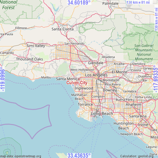
Culver City GPS coordinates[2]
34° 1' 16.032" North, 118° 23' 47.292" West
| Map corner | latitude | longitude |
|---|---|---|
| Upper-left | 34.60189°, | -119.0996° |
| Center: | 34.02112°, | -118.39647° |
| Lower-right: | 33.43635°, | -117.69335° |
| Map W x H: | 129.6×129.6 km | = 80.5×80.5mi |
| max Lat: | 71.29058° ⇑80.1% North |
| Culver City: | 34.02112° |
| min Lat: | ⇓19.9% South 19.06759° |
| min Long | Culver City | max Long |
| -171.73463° | -118.39647° | -66.98998° |
| W 8.5%⇐ | ⇒91.5% E |
Elevation
Elevation of Culver City is 35 m = 115 ft, and this is 259.8 m = 852 ft below average elevation for this country.
| Max E: |
3189 m = 10463 ft | 82.9% |
| Avg. | 294.8 m = 967 ft | |
| Culver City | 35 m = 115 ft | |
Min E: |
-60 m = -197 ft | 17.1% |
See also: United States elevation on elevation.city.
Geographical zone
Culver City is located in North temperate zone (between Tropic of Cancer and the Arctic Circle). Distance of this Northern Tropic circle is 1176.9 km =731.3 mi to South.| Distance of | km | miles | from Culver City |
|---|---|---|---|
| North Pole | 6224.3 | 3867.6 | to North |
| Arctic Circle | 3618.4 | 2248.4 | to North |
| Tropic Cancer | 1176.9 | 731.3 | to South |
| Equator | 3782.8 | 2350.5 | to South |


Nearby cities:
15 places around Culver City: (largest is in red/bold)
• Beverly Hills
5.8 km =3.6 mi,  356°
356°
• Century City
4.3 km =2.7 mi,  332°
332°
• Del Aire
11.9 km =7.4 mi,  167°
167°
• El Segundo
11.5 km =7.1 mi,  189°
189°
• Hollywood
10.7 km =6.6 mi,  36°
36°
• Inglewood
7.7 km =4.8 mi,  148°
148°
• Koreatown
9.7 km =6 mi,  65°
65°
• Ladera Heights
3.6 km =2.2 mi, 146°
• Lennox
10.1 km =6.3 mi,  156°
156°
• Marina del Rey
6.8 km =4.2 mi,  228°
228°
• Santa Monica
8.7 km =5.4 mi,  268°
268°
• Venice
6.8 km =4.2 mi,  240°
240°
• View Park-Windsor Hills
5.3 km =3.3 mi,  122°
122°
• West Hollywood
8.3 km =5.2 mi,  22°
22°
• Westwood
5 km =3.1 mi,  321°
321°
Sources, notices
• [Note1] Compared only with cities in United States existing in our database
• [Src1] Map data: © OpenStreetMap contributors (CC-BY-SA)
• [Src2] Other city data from geonames.org with taken over terms of usage.
• [Src3] Geographical zone / Annual Mean Temperature by Robert A. Rohde @ Wikipedia
