Inglewood geodata
Inglewood (California) is a populated place; located in United States in America/Los_Angeles (GMT-7) time zone. With population of 111,666 people, there are 295 cities with bigger population in this country. Compared to other cities in United States, 80.5% of cities are located further ↑North; 91.4% of cities are located further →East and 80.6% of cities have higher elevation than Inglewood. Note1


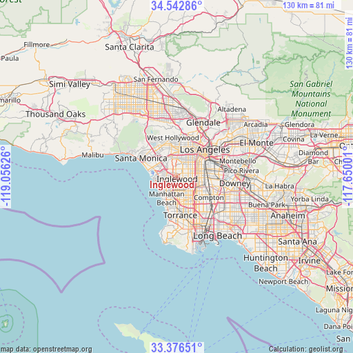
Inglewood GPS coordinates[2]
33° 57' 42.048" North, 118° 21' 11.268" West
| Map corner | latitude | longitude |
|---|---|---|
| Upper-left | 34.54286°, | -119.05626° |
| Center: | 33.96168°, | -118.35313° |
| Lower-right: | 33.37651°, | -117.65001° |
| Map W x H: | 129.7×129.7 km | = 80.6×80.6mi |
| max Lat: | 71.29058° ⇑80.5% North |
| Inglewood: | 33.96168° |
| min Lat: | ⇓19.5% South 19.06759° |
| min Long | Inglewood | max Long |
| -171.73463° | -118.35313° | -66.98998° |
| W 8.6%⇐ | ⇒91.4% E |
Elevation
Elevation of Inglewood is 44 m = 144 ft, and this is 250.8 m = 823 ft below average elevation for this country.
| Max E: |
3189 m = 10463 ft | 80.6% |
| Avg. | 294.8 m = 967 ft | |
| Inglewood | 44 m = 144 ft | |
Min E: |
-60 m = -197 ft | 19.4% |
See also: Inglewood elevation on elevation.city.
Geographical zone
Inglewood is located in North temperate zone (between Tropic of Cancer and the Arctic Circle). Distance of this Northern Tropic circle is 1170.3 km =727.2 mi to South.| Distance of | km | miles | from Inglewood |
|---|---|---|---|
| North Pole | 6230.9 | 3871.7 | to North |
| Arctic Circle | 3625 | 2252.5 | to North |
| Tropic Cancer | 1170.3 | 727.2 | to South |
| Equator | 3776.2 | 2346.4 | to South |


Nearby cities:
15 places around Inglewood: (largest is in red/bold)
• Alondra Park
8.3 km =5.2 mi,  165°
165°
• Culver City
7.7 km =4.8 mi,  328°
328°
• Del Aire
5.3 km =3.3 mi,  196°
196°
• El Segundo
7.5 km =4.7 mi,  231°
231°
• Florence-Graham
10.1 km =6.3 mi,  86°
86°
• Gardena
9.1 km =5.7 mi,  153°
153°
• Hawthorne
5 km =3.1 mi,  179°
179°
• Ladera Heights
4.2 km =2.6 mi, 330°
• Lawndale
8.3 km =5.2 mi, 179°
• Lennox
2.6 km =1.6 mi, 178°
• Manhattan Beach
10.1 km =6.3 mi,  211°
211°
• Marina del Rey
9.3 km =5.8 mi,  282°
282°
• View Park-Windsor Hills
3.8 km =2.4 mi,  6°
6°
• West Athens
6.3 km =3.9 mi,  132°
132°
• Westmont
5.2 km =3.2 mi,  115°
115°
Sources, notices
• [Note1] Compared only with cities in United States existing in our database
• [Src1] Map data: © OpenStreetMap contributors (CC-BY-SA)
• [Src2] Other city data from geonames.org with taken over terms of usage.
• [Src3] Geographical zone / Annual Mean Temperature by Robert A. Rohde @ Wikipedia
